- Cushing, Minnesota
-
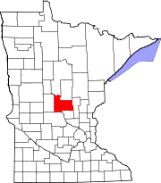
Cushing is a small unincorporated community in Morrison County, Minnesota, United States.
Contents
Geography
Cushing received its name from the township it is located within, Cushing Township. The town of Cushing has been assigned US zip code 56443. The town of Cushing is situated along U.S. Route 10 and County Road 5 (named Bear Road.) The latitude of Cushing is 46.148N. The longitude is -94.508W. It is in the Central Standard time zone. Elevation is 1,283 feet.
City structure
Cushing has one post office, one town hall building, two churches and one cemetery, a park, a bar (known to locals as 'The Elks' for its name, Elk Creek Saloon and Eatery(now closed)), and an abandoned gas station from the early 1900s. There are several residential homes located in Cushing. The BNSF Railway runs through Cushing and has since the late 19th century. The population, at the time of the 2000 census, was 632.
External links
References
Coordinates: 46°08′20″N 94°34′48″W / 46.138756°N 94.579964°W
Municipalities and communities of Morrison County, Minnesota Cities Townships Agram | Belle Prairie | Bellevue | Buckman | Buh | Culdrum | Cushing | Darling | Elmdale | Granite | Green Prairie | Hillman | Lakin | Leigh | Little Falls | Morrill | Motley | Mount Morris | Parker | Pierz | Pike Creek | Platte | Pulaski | Rail Prairie | Richardson | Ripley | Rosing | Scandia Valley | Swan River | Swanville | Two Rivers
Unincorporated
communityCushing
Indian
reservationFootnotes ‡This populated place also has portions in an adjacent county or counties
Categories:- Unincorporated communities in Minnesota
- Populated places in Morrison County, Minnesota
Wikimedia Foundation. 2010.

