- Bull Sluice Lake
-
Bull Sluice Lake 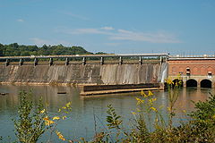
Morgan Falls Dam Location Fulton / Cobb counties, Georgia Coordinates 33°58′01″N 84°22′52″W / 33.967°N 84.381°WCoordinates: 33°58′01″N 84°22′52″W / 33.967°N 84.381°W Primary inflows Chattahoochee River Primary outflows Chattahoochee River PPS 1500
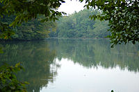
Basin countries United States Surface area 673.6 acres (3 km2) Average depth 27 ft (8.2 m) Max. depth 55 feet (17 m) Surface elevation 797 feet (243 m) Settlements Roswell, Georgia Bull Sluice Lake is a small reservoir located along the Chattahoochee River in northern Georgia, in the northern suburbs of metro Atlanta. It is 673 acres (2.72 km2), and is impounded by Morgan Falls Dam. Besides the hydroelectric power produced by the dam, the lake's primary use is recreation, including fishing and rowing. It also now helps to buffer releases by Buford Dam, from the much larger (by 500 times) Lake Lanier, 36 miles (58 km) upstream.
 Bull Sluice Lake
Bull Sluice Lake is created by Morgan Falls Dam, a small hydroelectric dam located along the Chattahoochee River at the northern end of Sandy Springs, Georgia, in north metro Atlanta, located in East Cobb County. Originally constructed in 1904 by Georgia Power to provide electricity for Atlanta's streetcars, it now provides enough power for about 4400 homes. It was named for then recently deceased Georgia Power president S. Morgan Smith's mother whose maiden name was Morgan. At the time it was by far the largest hydroelectric plant in the state. [1] In 1924 it was rebuilt as a 60 cycle plant with 15,000 kilowatts (up from the original 10,500kW).[2] In 1957 it was raised to regulate the flow from Buford Dam in order to give Atlanta water during the hours it was needed most. [3] It is 896 feet or 314 meters long, and 56 feet or 17 meters tall. The dam's current license from the Federal Energy Regulatory Commission (FERC) was issued in March 1959, and expires in February 2009. Georgia Power has begun the required impact studies for re-licensing of the dam, which will be for 30 or 50 years.
Morgan Falls Dam • Plant Bowen • Plant Atkinson • Plant Vogtle
Nora Mill Dam · Lake Lanier · Bull Sluice Lake · West Point Lake · Langdale Dam · Crow Hop Dam · Riverview Dam · Lake Harding · Goat Rock Lake · Lake Oliver · North Highlands Dam · City Mills Dam · Eagle & Phenix Dam · Walter F. George Lake · George W. Andrews Lake · Lake Seminole
References
External links
- Georgia DNR's Bull Sluice Lake Page
- U.S. Geological Survey Geographic Names Information System: Bull Sluice Lake
- Georgia Power's Morgan Falls Page
Categories:- Georgia Power
- ACF basin
- Protected areas of Cobb County, Georgia
- Dams in Georgia (U.S. state)
- History of Atlanta, Georgia
- Reservoirs in Georgia (U.S. state)
- Roswell, Georgia
- Buildings and structures completed in 1904
- Protected areas of Fulton County, Georgia
- Georgia (U.S. state) geography stubs


Wikimedia Foundation. 2010.