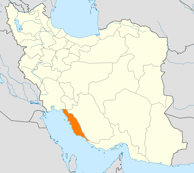
- Dashti County
-
Dashti County
شهرستان دشتی— County — Coordinates: 28°29′N 51°33′E / 28.483°N 51.55°ECoordinates: 28°29′N 51°33′E / 28.483°N 51.55°E Country  Iran
IranProvince Bushehr Province Capital Borazjan Bakhsh (Districts) Central District, Kaki District, Shonbeh and Tasuj District Population (2006) – Total 71,285 Time zone IRST (UTC+3:30) – Summer (DST) IRDT (UTC+4:30) Dashti County can be found at GEOnet Names Server, at this link, by opening the Advanced Search box, entering "9206094" in the "Unique Feature Id" form, and clicking on "Search Database". Dashti County (Persian: شهرستان دشتی) is one of the nine counties (shahrestans) in Bushehr Province, Iran. It has an area of 5,008 km². At the 2006 census, the county's population was 71,285, in 15,465 families.[1] The population is Muslim and they speak various forms of Persian languages including Farsi and the local Dashti. The capital of the county is Khvormuj. The county is subdivided into three districts: the Central District, Kaki District, and Shonbeh and Tasuj District. The county has three cities: Kaki, Khvormuj, and Shonbeh.
Dashti County is bounded by the Persian Gulf to the west, Tangestan County to the north and west, Dashtestan County to the northeast, Dayyer County and Kangan County and to the south, Jam County to the southeast, and Firuzabad County to the east. Its central geographic coordinates are: Longitude: 51 10 - 52 10 N, Latitude: 28 10 – 28 45 E
Dashti County has a 25 km coastline along the Persian Gulf, with a climate that is mostly arid or semiarid. The highest point in the county is Mount Beyrami at 1,950 m. Petroleum, natural gas, lime, and stone from quarries are extracted in the county. Wheat, tomatoes, corn, and other grains are grown. There is a local honey industry.
Tourist attractions
- Khormooj fortress
- Dokhtar fortress, located in Lavar-e saheli village
- Darab khan fortress, located in Shonbeh village
- Bahman dan fortress, located in Kaki city
- Mond temple
- Shirine building
- Mond River
- Mount Beyremi
- Mir Aram tomb
- Seyyed Mohammad Amin tomb, located in Kaki city
- Pir hashem tomb, located in Jabri village
- Shahzade Mohammad tomb, located in Sheikhyan village
- Dike Dojhtar, located in the Kaki city
- Baghan village
- Laver-e sharqi village
References
- ^ "Census of the Islamic Republic of Iran, 1385 (2006)" (Excel). Islamic Republic of Iran. http://www.amar.org.ir/DesktopModules/FTPManager/upload/upload2360/newjkh/newjkh/18.xls.
- اطلس گیتاشناسی استانهای ایران [Atlas Gitashenasi Ostanhai Iran] (Gitashenasi Province Atlas of Iran)
 Bushehr Province
Capital 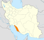
Counties and Cities Dashti CountyBandar Ganaveh · Bandar RigJam · RizLandmarks Ghavam water tank (Ab Anbar of Ghavam) · Khourmoj fire temple · Boraazjan Castle · Siraf · Seensiz · Rishahr · Chehelkhaneh cave · Bardak Siah Palace · Saadat Mozaffari School · Rais Ali Museum · Bushehr anthropology MuseumCategories:- Dashti County
- Counties of Iran
- Counties of Bushehr Province
- Iran geography stubs
Wikimedia Foundation. 2010.