- Deyr County
-
Deyr County
شهرستان دَیِّر— County — Gomroke.Deyr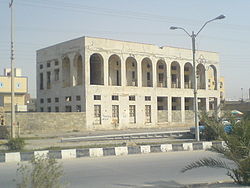
Coordinates: 28°02′N 51°42′E / 28.033°N 51.7°ECoordinates: 28°02′N 51°42′E / 28.033°N 51.7°E Country  Iran
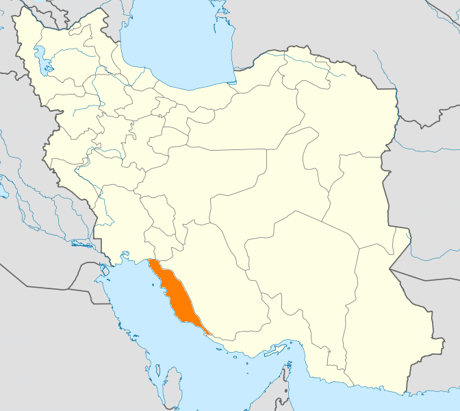
IranProvince Bushehr Province Capital Borazjan Bakhsh (Districts) Central District, Bord Khun District Population (2006) - Total 48,488 Time zone IRST (UTC+3:30) - Summer (DST) IRDT (UTC+4:30) Deyr County can be found at GEOnet Names Server, at this link, by opening the Advanced Search box, entering "9206095" in the "Unique Feature Id" form, and clicking on "Search Database". Deyr County (Persian: شهرستان دَیِّر) is a county in Bushehr Province in Iran. The capital is Bandar Deyr (Persian: بندر دَیِر). At the 2006 census, the county's population was 48,488, in 10,036 families.[1] The county is subdivided into two districts: the Central District and Bord Khun District. The county has four cities: Bandar Deyr, Bord Khun (Persian: بُردِخون), Abdan (Persian: آبدان), and Bardestan (Persian: بَردِستان).
Deyr county is one of the nine counties in Bushehr Province, Iran. It has an area of 4000 sqkm.[citation needed]
Some historians believe that Deyr county was exclusively inhabited by Jews, but by years the Muslims settled in the county, plus a large proportion of Deyr county’s Jews converted to Islam during the Safavid dynasty.[citation needed] The population nowadays is Muslim while the Jewish inhabitants has left the county in 1979, Persians, Arabs, Hebrews, Sumerians & Blacks are the major races in Deyr, the citizens of Deyr speaks various forms of Persian languages including Farsi and the local Deyri.[citation needed] The capital of the county is Bandar Deyr which is considered as prominent harbor in Persian Gulf.
Deyr County is bounded by the Persian Gulf to the west & south, Tangestan County & Dashti county to the north, Kangan County and Jam County to the east.
Deyr County has a climate that is mostly arid or semiarid. The highest point in the county is Mount Drang at 1,223 m. Natural gas extracted in the county. Wheat, tomatoes, corn, and other grains are grown. There is a local Fishing industry.
Deyr county includes three small towns & four villages, besides several small islands such as Khan island and it has an area of 800 hectares, Nakhilu island and it has an area of 75 hectares.
Climate & Water: Deyr county has a very hot & humid summer, the temperature could reach 47 °C some times. Mond River is the only river in Deyr county, and there is plenty of spring water.
Animal & Birds: Deyr county has variant animals & birds species such as camels, deer, foxes, rabbites, owls, hawks & Flamingo, while caracals, striped hyenas, wolves & Jackels rarely can be sighted. Mond natural reservation has an area of 464 sqkm, it conserve local animals and plants.
References
- ^ "Census of the Islamic Republic of Iran, 1385 (2006)" (Excel). Islamic Republic of Iran. http://www.amar.org.ir/DesktopModules/FTPManager/upload/upload2360/newjkh/newjkh/18.xls.
- پایگاه خبری دیر نت [Deyr net] (Dayyer net)
- اطلس گیتاشناسی استانهای ایران [Atlas Gitashenasi Ostanhai Iran] (Gitashenasi Province Atlas of Iran)
 Bushehr Province
Capital 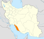
Counties and Cities Deyr CountyBandar Ganaveh · Bandar RigJam · RizLandmarks Ghavam water tank (Ab Anbar of Ghavam) · Khourmoj fire temple · Boraazjan Castle · Siraf · Seensiz · Rishahr · Chehelkhaneh cave · Bardak Siah Palace · Saadat Mozaffari School · Rais Ali Museum · Bushehr anthropology MuseumCategories:- Deyr County
- Counties of Iran
- Counties of Bushehr Province
- Iran geography stubs

Wikimedia Foundation. 2010.