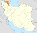
- Nir County
-
Nir County
شهرستان نیر— County — Coordinates: 38°00′N 48°05′E / 38°N 48.083°ECoordinates: 38°00′N 48°05′E / 38°N 48.083°E Country  Iran
IranProvince Ardabil Province Capital Nir Bakhsh (Districts) Central District, Kuraim District Population (2006) – Total 23,573 Time zone IRST (UTC+3:30) – Summer (DST) IRDT (UTC+4:30) Nir County at GEOnet Names Server Nir County (Persian: شهرستان نیر) is a county in Ardabil Province in Iran. The capital of the county is Nir. At the 2006 census, the county's population was 23,573, in 5,411 families.[1] The county consists of two districts: the Central District and Kuraim District. The county has two cities: Nir and Kuraim.
References
- ^ "Census of the Islamic Republic of Iran, 1385 (2006)" (Excel). Islamic Republic of Iran. http://www.amar.org.ir/DesktopModules/FTPManager/upload/upload2360/newjkh/newjkh/24.xls.
- اطلس گیتاشناسی استانهای ایران [Atlas Gitashenasi Ostanhai Iran] (Gitashenasi Province Atlas of Iran)
 Ardabil Province
Capital 
Counties and Cities Ardabil · HirBileh Savar CountyBileh Savar · JafarabadGermi · Tazeh Kand-e AgutiKhalkhal · Hashatjin · KolowrKiviNir CountyNir · KuraimParsabad · Aslan DuzSareyn CountyLandmarks Sardabe Waterfall · Complex of Sheikh Safi-ad-din Ardabili · Emamzadeh Klouver · Ardabil Bazaar · Alvares (ski resort) · Shorabil · Sabalan · Neor lake · Shapur II Bas-relief of Meshkinshar · Haftkhaneh Cave · Sarein springs · Ardabil Anthropology Museum · Qarah Soo BridgeCategories:- Nir County
- Counties of Iran
- Counties of Ardabil Province
- Ardabil Province geography stubs
Wikimedia Foundation. 2010.
