- Delano Municipal Airport
-
Delano Municipal Airport 
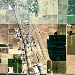
USGS aerial photo as of 2006 IATA: none – ICAO: KDLO – FAA LID: DLO Summary Airport type Public Owner City of Delano Serves Delano, California Elevation AMSL 314 ft / 96 m Coordinates 35°44′44″N 119°14′11″W / 35.74556°N 119.23639°W Runways Direction Length Surface ft m 14/32 5,651 1,722 Asphalt Statistics (2006) Aircraft operations 19,000 Based aircraft 44 Source: Federal Aviation Administration[1] Delano Municipal Airport (ICAO: KDLO, FAA LID: DLO) is a public airport located two miles (3 km) southeast of the central business district of Delano, a city in Kern County, California, United States. It is owned by the City of Delano.[1]
Although most U.S. airports use the same three-letter location identifier for the FAA and IATA, Delano Municipal Airport is assigned DLO by the FAA but has no designation from the IATA.[2]
Contents
Facilities and aircraft
Delano Municipal Airport covers an area of 546 acres (221 ha) which contains one asphalt paved runway (14/32) measuring 5,651 x 75 ft (1,722 x 23 m).[1]
For the 12-month period ending January 23, 2006, the airport had 19,000 aircraft operations, an average of 52 per day, all of which were general aviation. There are 44 aircraft based at this airport: 68% single engine, 5% multi-engine and 27% helicopters.[1]
History
Delano Airport was opened in April 1940. It was built by the Federal Government with monies appropriated by Congress for Development of Landing Areas for National Defense (DLAND) as a result of World War II breaking out in Europe during 1939. It was constructed by the Civil Aeronautics Administration (CAA).
In late 1943, The United States Army Air Forces acquired usage rights to the airport. It was placed under the jurisdiction of the IV Fighter Command. The 481st Night Fighter Operational Training Group (NFOTG) used the faciity, named Delano Army Airfield as part of the Army Air Forces Night Fighter School which had transferred from Florida to Hammer Field, California. Delano was used as an auxiliary training airfield and the school operated a combination of modified Douglas A-20 Havocs for night fighter operations, designated P-70, and brand-new prototype YP-61 Black Widow purpose-built night fighters
Between 31 March and 15 June 1944, the 426th Night Fighter Squadron trained at Delano; the 548th Night Fighter Squadron between June and September 1944. In addition, flights of P-61s from the 427th, 547th, 549th and 550th Night Fighter Squadrons moved in and out of Delano AAF during 1944 as part of their training prior to being deployed to combat units, primarily in the Pacific and CBI theaters.
In December 1944, the 481st NFOTG was inactivated as part of an AAF reorganization. Delano Field was transferred over to the jurisdiction of Air Technical Service Command on 10 December. It was placed on standby status and the airport was only used for emergency purposes, being under the control of Hammer Field.
With the end of the war, the base was declared excess to requirements and returned to civil control.
See also
References
 This article incorporates public domain material from websites or documents of the Air Force Historical Research Agency.
- ^ a b c d FAA Airport Master Record for DLO (Form 5010 PDF), effective 2007-07-05
- ^ Great Circle Mapper: KDLO - Delano, California (Delano Municipal Airport)
External links
- FAA Terminal Procedures for DLO, effective 20 October 2011
- Resources for this airport:
- AirNav airport information for DLO
- FlightAware airport information and live flight tracker
- SkyVector aeronautical chart for DLO
Categories:- 1940 establishments
- Airports in Kern County, California
- Central Valley of California
- Airfields of the United States Army Air Forces Technical Service Command
- Airfields of the United States Army Air Forces in California
- California airport stubs
Wikimedia Foundation. 2010.
