- Cookley
-
For the village in Suffolk, see Cookley, Suffolk.
Coordinates: 52°25′04″N 2°14′12″W / 52.41776°N 2.23668°W
Cookley 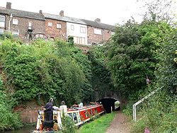
Eastern portal of Cookley Tunnel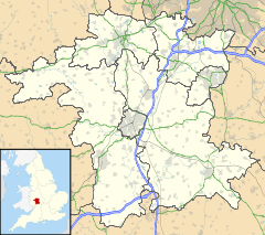
 Cookley
Cookley shown within WorcestershireOS grid reference SO8480 District Wyre Forest Shire county Worcestershire Region West Midlands Country England Sovereign state United Kingdom Post town KIDDERMINSTER Postcode district DY11 Police West Mercia Fire Hereford and Worcester Ambulance West Midlands EU Parliament West Midlands UK Parliament Wyre Forest List of places: UK • England • Worcestershire Cookley is a village in the Wyre Forest District of Worcestershire, England, a few miles to the north of Kidderminster, and close to the villages of Kinver and Wolverley. It lies on the River Stour, and the Staffordshire and Worcestershire Canal in the civil parish of Wolverley and Cookley. At the time of the 2001 census had a population of 2,491.[1]
Village
Commerce within the village include a butchery, a post office and a tandoori – all of which are family-run. It also has a Tesco Express.
The village cricket team, which was founded in 1869, won the Haig Village Cricket Knockout Cup in 1977, beating Lindal Moor at Lord's.
The village is often used as a case study for the OCR GCSE geography course.
References
External links
- Cookley Community Website
- photos of Cookley and surrounding area on geograph
- Cookley Cricket Club's Official Website
Towns Villages Areley Kings • Astley Cross • Axborough • Blakedown • Blakeshall • Bliss Gate • Broome • Caunsall • Chaddesley Corbett • Churchill • Clows Top • Cookley • Drayton • Franche • Heightington • Kingsford • Ribbesford • Rock • Rushock • Shenstone • Stone • Tanwood • Upper Arley • WolverleyCivil parishes Categories:- Villages in Worcestershire
- Worcestershire geography stubs


Wikimedia Foundation. 2010.