- Grande Ronde River
Geobox River
name = Grande Ronde River
native_name =
other_name =
other_name1 =
image_size =
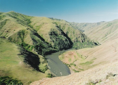
image_caption = Grande Ronde near the Washington/Oregon border.
country = United States
country1 =
state = Oregon
state1 = Washington
region =
region1 =
district =
district1 =
city = La Grande
city1 = Elgin
length_imperial = 212
length_note = [http://www.nwcouncil.org/fw/subbasinplanning/granderonde/plan/GRSPfinal.pdf Grande Ronde Subbasin Plan] , Northwest Power and Conservation Council]
watershed_imperial = 4000
watershed_note =
discharge_location = below Wenaha River, near Troy, OR
discharge_imperial = 3034
discharge_max_imperial = 42200
discharge_min_imperial = 344
discharge_note = [http://pubs.usgs.gov/wdr/2005/wdr-or-05/ Water Resources Data, Oregon, 2005] , USGS]
discharge1_location =
discharge1_imperial =
source_name = Blue Mountains
source_location = Elkhorn Range
source_district =
source_region =
source_state =
source_country =
source_lat_d = 44
source_lat_m = 57
source_lat_s = 34
source_lat_NS = N
source_long_d = 118
source_long_m = 15
source_long_s = 38
source_long_EW = W
source_coordinates_note = Gnis|1505215|Grande Ronde River, USGS, GNIS]
source_elevation_imperial = 7444
source_elevation_note =Google Earth elevation for GNIS coordinates.]
source_length_imperial =
mouth_name = Snake River
mouth_location =
mouth_district =
mouth_region =
mouth_state =
mouth_country =
mouth_lat_d = 46
mouth_lat_m = 4
mouth_lat_s = 49
mouth_lat_NS = N
mouth_long_d = 116
mouth_long_m = 58
mouth_long_s = 47
mouth_long_EW = W
mouth_coordinates_note =
mouth_elevation_imperial = 830
mouth_elevation_note =
tributary_left = Wenaha River
tributary_left1 =
tributary_left2 =
tributary_left3 =
tributary_left4 =
tributary_right = Catherine Creek
tributary_right1 = Wallowa River
tributary_right2 = Joseph Creek
tributary_right3 =
free_name =
free_value =
map_size =
map_caption = :"For other places with the same name, seeGrande Ronde ."The Grande Ronde River is a tributary of the
Snake River , convert|212|mi|km long, in northeasternOregon and southeasternWashington in theUnited States . It drains an area southeast of the Blue Mountains, and northwest of theWallowa Mountains , on theColumbia Plateau . It flows through the agriculturalGrande Ronde Valley in its middle course and through a series of sceniccanyon s in its lower course.Course
The Grande Ronde River rises in the Blue Mountains near the Anthony Lakes recreation area in the
Wallowa-Whitman National Forest in southwestern Union County approximately convert|20|mi|km south of La Grande. It flows generally north along the east side of the Blue Mountains, then east, past La Grande, then generally northeast through the Grande Ronde Valley in ameander ing course between the Blue Mountains and theWallowa Mountains , receiving Catherine Creek east of La Grande.Approximately convert|10|mi|km northwest of Minam it receives the
Wallowa River from the southeast, then receives theWenaha River at Troy just south of the Washington border. It crosses into southeastern Washington, traversing the extreme southeast corner of the state and entering the Snake from the east, approximately convert|5|mi|km north of the Oregon border and convert|15|mi|km downstream from the mouth of the Salmon River. It receives Joseph Creek from the south convert|2|mi|km upstream from its mouth on the Snake.The mouth of the Grande Ronde River is located at the Snake's
river mile 169, which is convert|493|mi|km from the mouth of the Columbia River.River modifications
A diversion channel approximately convert|5|mi|km long in the Grande Ronde Valley east of La Grande allows the river to bypass a long meandering loop, providing each access to its water for
irrigation .History
In the early 19th century the valley of the river was inhabited by
Nez Perce , Umatilla, Walla Walla, andCayuse tribes of Native Americans. Numerous archaeological sites are on the public land around the river.The Grande Ronde River was given its name sometime before 1821 by
French Canadian voyageurs working for the Montreal-based fur tradingNorth West Company . [cite book |last= Mackie |first= Richard Somerset |title= Trading Beyond the Mountains: The British Fur Trade on the Pacific 1793-1843 |year= 1997 |publisher= University of British Columbia (UBC) Press |location= Vancouver |isbn= 0-7748-0613-3 |pages= p. 26]In 1988, the
United States Congress designated approximately convert|44|mi|km of the river, from its confluence with the Wallowa River to the Oregon-Washington border, as the Grande Ronde Wild and Scenic River, as part of theNational Wild and Scenic River program.The river today is popular destination for
hunting , especially for game animals such asmule deer , elk, black bear,cougar , andbighorn sheep . Fishing, rafting and hiking are also popular along the designated Wild and Scenic portion of the river. Most of the middle reaches of the river are inaccessible to motor vehicles.Fish
The Grand Ronde River supports populations of spring
chinook salmon, summersteelhead ,bull trout ,mountain whitefish , as well as other species. The river has a sport steelhead fishery and has some tribal fishing for spring chinook.ee also
*
List of Oregon rivers
*Joseph Canyon References
External links
* [http://www.rivers.gov/wsr-grande-ronde.html Grande Ronde Wild and Scenic River]
Wikimedia Foundation. 2010.