Old Haulover Canal

Old Haulover Canal

Infobox nrhp
name = Old Haulover Canal


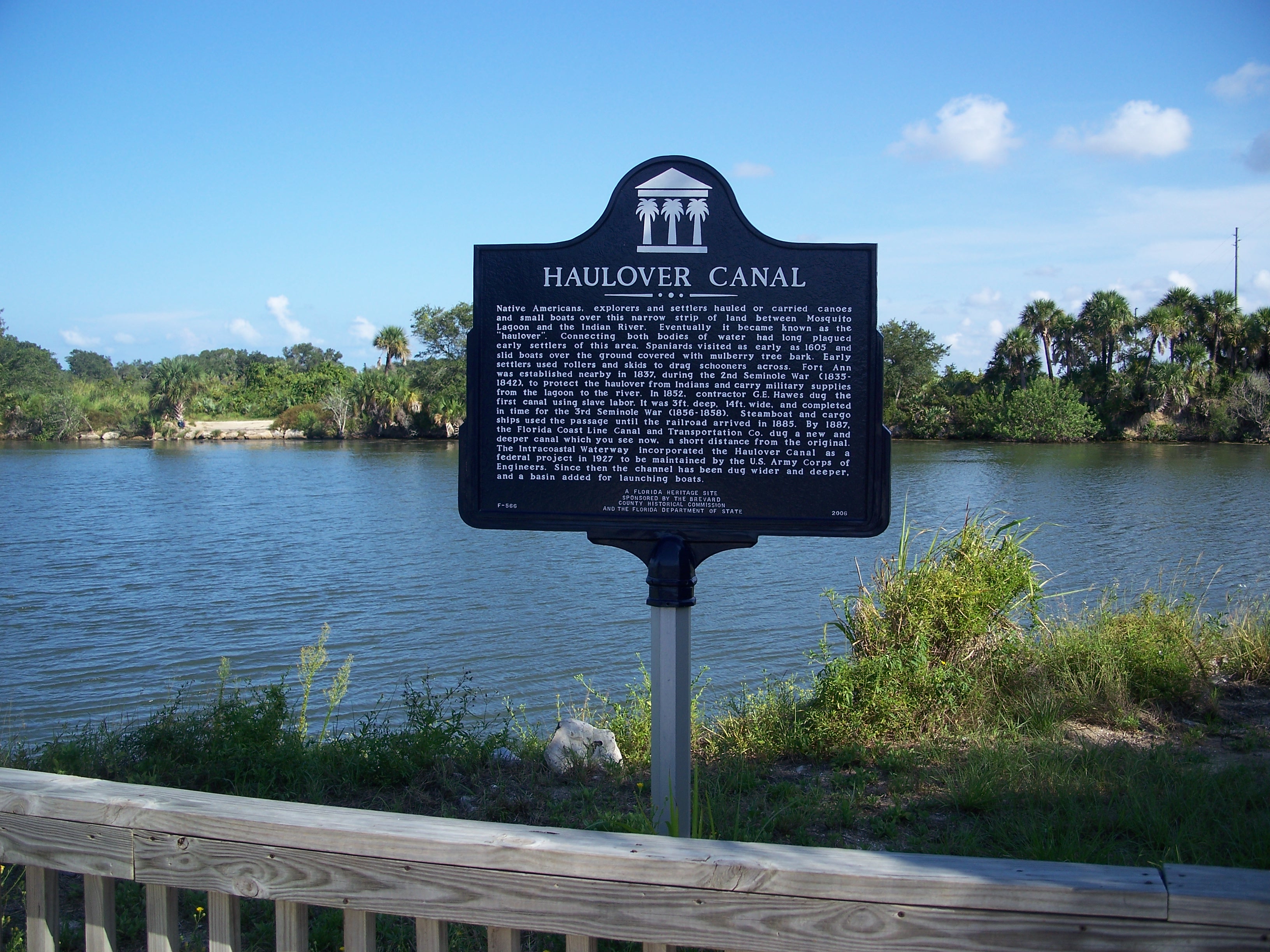
caption = Historic marker, with canal in background
location = Brevard County, Florida
nearest_city = Merritt Island
lat_degrees = 28
lat_minutes = 44
lat_seconds = 11
lat_direction = N
long_degrees = 80
long_minutes = 45
long_seconds = 17
long_direction = W
area =
added = December 19, 1978
visitation_num =
visitation_year =
governing_body =
The Old Haulover Canal is a historic location north of Merritt Island, Florida. On December 19, 1978, it was added to the U.S. National Register of Historic Places.

References and external links

* [http://www.nationalregisterofhistoricplaces.com/FL/Brevard/state.html Brevard County listings] at [http://www.nationalregisterofhistoricplaces.com National Register of Historic Places]
* [http://www.flheritage.com Florida's Office of Cultural and Historical Programs]
** [http://www.flheritage.com/facts/reports/places/index.cfm?fuseaction=ListAreas&county=brevard Brevard County listings]
** [http://www.flheritage.com/preservation/markers/markers.cfm?ID=brevard Brevard County markers]
** [http://www.flheritage.com/services/sites/fht/record_t.cfm?ID=70&type=c&index=5 Old Haulover Canal]


Wikimedia Foundation. 2010.

Игры ⚽ Поможем написать реферат

Look at other dictionaries:

  • Haulover Canal — Date completed 1887 Status Open Navigation authority U.S. Army Corps of Engineers The Haulover Canal is a waterway north of Merritt Island, Florida, near the former site of Allenhurst, that connects Mosquito Lagoon with the Indian River, and is… …   Wikipedia

  • National Register of Historic Places listings in Brevard County, Florida — Location of Brevard County in Florida This is a list of the National Register of Historic Places listings in Brevard County, Florida. This is intended to be a complete list of the properties and districts on the National Register of Historic… …   Wikipedia

  • Merritt Island, Florida — For the Yolo County, California island, see Merritt Island AVA. Merritt Island, Florida   CDP   …   Wikipedia

  • Shiloh, Florida — For the place in Alachua County, see Shiloh, Alachua County, Florida Shiloh was a village in Brevard County, Florida, United States. It s the northernmost place in Brevard County. Scottsmoor also shares the title, across the Indian River. However …   Wikipedia

  • St. Peter's, Nova Scotia — Infobox Settlement official name = Pagename other name = native name = nickname = settlement type = Village motto = Gateway to the Bras d Or imagesize = image caption = flag size = image seal size = image shield = shield size = city logo =… …   Wikipedia

  • Miami River (Florida) — Miami River The mouth of the Miami River at Brickell Key (February 2010). Origin The Everglades Mouth Brick …   Wikipedia

  • Chattahoochee River — Coordinates: 30°42′32″N 84°51′50″W / 30.70889°N 84.86389°W / 30.70889; 84.86389 …   Wikipedia

  • Ochlockonee River — Coordinates: 29°58′36″N 84°26′15″W / 29.97667°N 84.4375°W / 29.97667; 84.4375 …   Wikipedia

  • Choctawhatchee River — Map of Choctawhatchee River Origin Barbour County, Alabama …   Wikipedia

  • Miami Beach, Florida — Miami Beach redirects here. For the beach in Barbados, see Miami Beach, Barbados. See also: South Beach and North Beach (Miami Beach) Miami Beach City of Miami Beach   City   …   Wikipedia

Share the article and excerpts

Direct link
Do a right-click on the link above
and select “Copy Link”