- Öskjuvatn
-
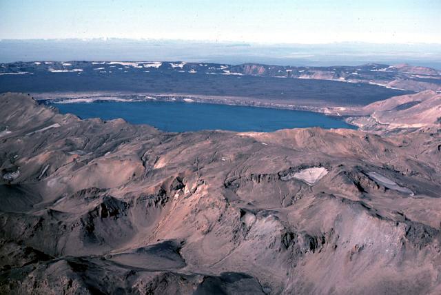
Öskjuvatn 
Coordinates 65°02′N 16°45′W / 65.033°N 16.75°WCoordinates: 65°02′N 16°45′W / 65.033°N 16.75°W Basin countries Iceland Surface area 11 km² Max. depth 217 m (712 ft)[1] Öskjuvatn is a lake in the Highlands of Iceland. Its surface area is about 11 km². With a depth of 217 m (712 ft), it is the deepest lake in Iceland.[1]
The lake is situated in the crater of the volcano Askja in the north-east of the glacier Vatnajökull. Its name simply means the lake of Askja. Like the neighbouring crater Víti, it was created by an enormous volcanic eruption in 1875.
On July 10, 1907, two German scientists, Walter von Knebel and Max Rudloff disappeared while exploring the lake in a small boat. Knebel's fiancée, Ina von Grumbkow, led an expedition in search of them, but no trace of them was ever found. Suppositions at the time suggested that seismic volcanic disturbances could have caused a landslip or similar occurrence, and recorded that only two days previously the telegraph cable to Iceland had been broken by deep water disturbances for the first time since it was laid, close to the Icelandic coast.
See also
- Geography of Iceland
- Glaciers of Iceland
- Iceland plume
- Lakes of Iceland
- List of islands off Iceland
- List of volcanoes in Iceland
- Rivers of Iceland
- Volcanism in Iceland
- Waterfalls of Iceland
- Geographical Journal Jan 1910
References
- ^ a b "Rivers and Lakes". Iceland.is. http://www.iceland.is/country-and-nature/nature/RiversandLakes/. Retrieved 19 April 2010.
External links
Lakes of Iceland Apavatn · Blöndulón · Breiðárlón · Elliðavatn · Fjallsárlón · Frostastaðavatn · Grænalón · Grímsvötn · Hóp · Hreðavatn · Hvalvatn · Hvítárvatn · Hvítavatn · Jökulsárlón · Kleifarvatn · Kvíslavatn · Lagarfljót · Langisjór · Laugarvatn · Mývatn · Öskjuvatn · Sigöldulón · Skorradalsvatn · Sultartangalón · Svínavatn · Þingvallavatn · Þórisvatn · Tjörnin Categories:
- Lakes of Iceland
- Volcanoes of Iceland
- Crater lakes
- Iceland North Volcanic Zone
Wikimedia Foundation. 2010.