- Crown Street, Wollongong
-
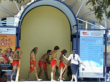 Australian Aborigines performing at Crown Street Mall
Crown Street is the main street in the city of Wollongong, New South Wales. It was created in the early 19th century from a cattle track which follows a ridge from Mount Keira to the first farm house in the area, and quickly became the "main" street of the then town.
Today Crown Street is the main arterial route through Wollongong from the southern suburbs to the north east. Along its route it features Wollongong Hospital, the Piccadilly Centre, Wollongong railway station, and the now-abandoned PMG building. Crown Street has also now become a major shopping district after being partially converted into a mall in the mid 1980s.
Crown Street Mall
The pedestrian-only zone of Crown Street Mall stretches from the corner of Crown and Keira Streets in the west to the corner of Crown and Kembla Streets in the east - these cross streets being named after the local mountains Mount Keira and Mount Kembla respectively. The mall had originally included two distinctive archways as well as several fountains and architectural features, however the archways in on the junction of Crown and Keira Streets have since been demolished to make room for a pedestrian bridge. There is currently a revitalisation scheme under way and possible options include converting this area to al fresco dining for night shoppers and opening it to slow moving traffic.
The two main buildings are Crown Tower and Gateway. They both started in the 1970s as independent shopping centres but are now joined as Wollongong Central. Gateway used to have a food court but this was replaced by a medical centre in the early 21st century.
The council has announced that the mall will go through a major facelift beginning in early 2012.[1]
The mall & Crown Central (now Wollongong Central, formerly Gateway) include the following shops and centres:
- David Jones department store
- Myer department store
- Angus and Robertson books
- Harrison's Chemists
- Tramps Menswear
- McDonald's
- Sanity Music
- Surf Dive 'n' Ski
- JayJays
- Gloria Jeans
- Rebel Sport
- Wendy's Supa Sundaes
- Lowes
- Gloss
- Temt
- Just Jeans
- The Rock Factory
- Redback Music
- The Body Shop
- Best and Less
- JB Hi-Fi
- Uncle Pete's Toys
- Williams The Shoemen
- EB Games
- Chica Booti
Each Friday the lower mall area is converted into a local market.
References
External links
Categories:- Wollongong
- Pedestrian malls in Australia

Wikimedia Foundation. 2010.