- Dundas Aqueduct
-
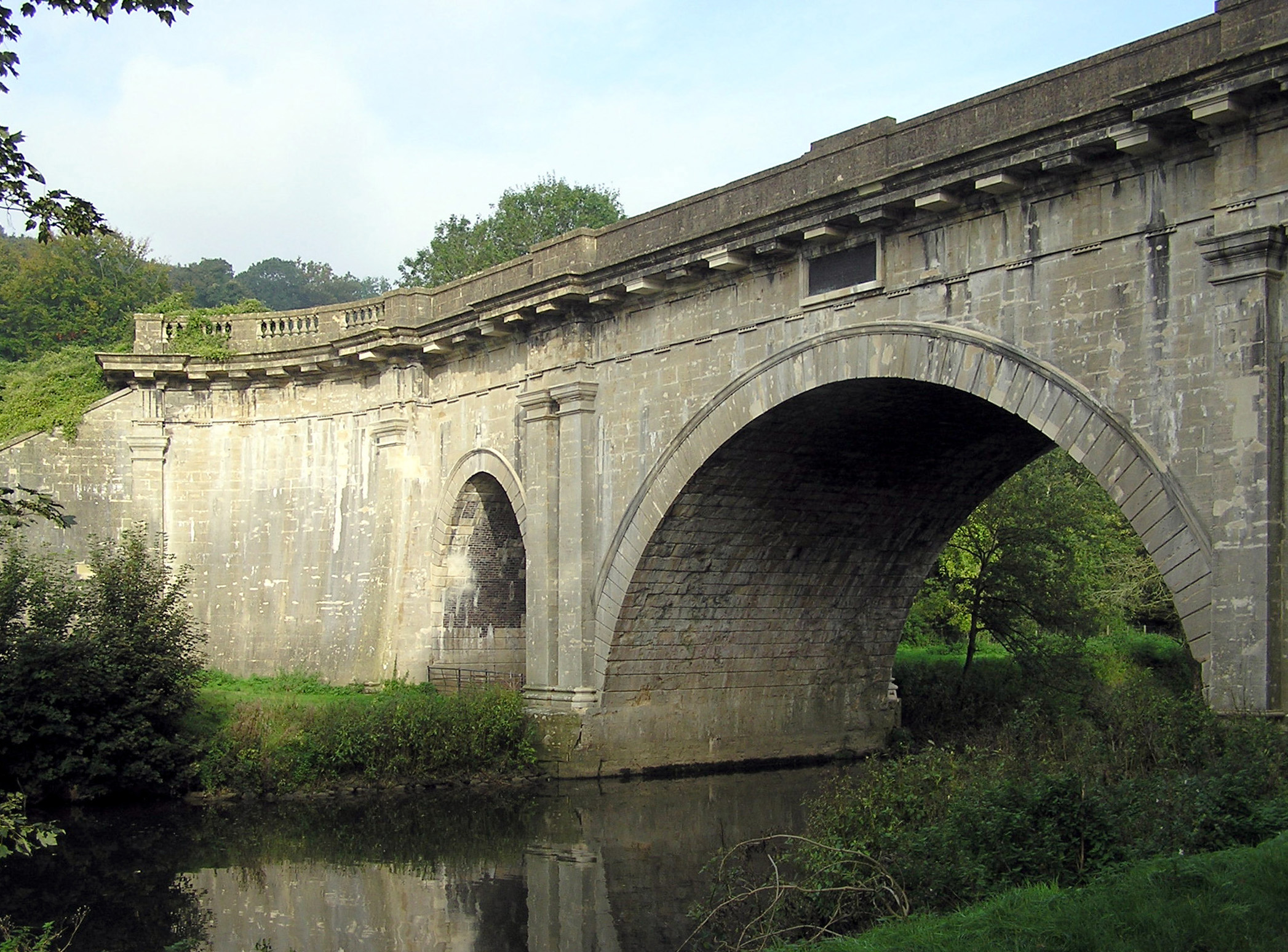
Dundas Aqueduct 
Carries Kennet and Avon Canal Crosses River Avon & Wessex Main Line Location Limpley Stoke OS grid reference Maintained by British Waterways Designer John Rennie Pier construction Bath Stone Longest span 65 feet (19.8 m) Total length 150 yards (137.2 m) Begin date 1797 Completion date 1801 Opening date 1805 Date of major rebuild 1984 Heritage status Grade I Coordinates 51°21′42″N 2°18′38″W / 51.3616°N -2.3105°ECoordinates: 51°21′42″N 2°18′38″W / 51.3616°N -2.3105°E  Dundas Aqueduct (the narrow section of canal in the picture) taken from the western end
Dundas Aqueduct (grid reference ST785625) carries the Kennet and Avon Canal over the River Avon and the Wessex Main Line railway from Bath to Westbury, near Limpley Stoke in Wiltshire, England.
It was built by John Rennie and chief engineer John Thomas, between 1797 and 1801 and completed in 1805. James McIlquham was appointed contractor.[1] It is named after Charles Dundas, the first chairman of the Kennet and Avon Canal Company. The aqueduct is 150 yards (137.2 m) long with three arches built of Bath Stone, with Doric pilasters, and balustrades at each end.[2] The central semicircular arch spans 64 feet (19.5 m); the two oval side arches span 20 feet (6.1 m).[3] It is a grade I listed building,[4] and was the first canal structure to be designated as an Scheduled Ancient Monument in 1951.
Over many years leaks had developed and it was closed in 1954. For a while in the 1960s and 1970s, the canal was dry and it was possible to walk along the bed on each side of the river as well as through the aqueduct itself. The aqueduct was relined, with polythene and concrete and restored, reopening in 1984.[5] Care was taken not to disturb a colony of bats living under the aqueduct.[2]
 The Dundas Aqueduct from the eastern end. The canal boat in the picture can turn left to moorings on the only remaining section of the Somerset Coal Canal or turn right to traverse the last few miles of the canal into the city of Bath. The walls of the Aqueduct can be seen on left and right, the river and railway are unseen far below.
The aqueduct is also the junction between the Kennet and Avon Canal and the largely derelict Somerset Coal Canal. The short stretch of the Somerset Coal Canal still with water in it forms Brassknocker Basin, used for boat moorings, cycle hire and a cafe.[6] and is next to Dundas Wharf where the small tollhouse, warehouse and crane still stand. Renovation work is being conducted on the wharf. The stretch of river below and above the aqueduct is used by Monkton Combe School Boat Club (Monkton Bluefriars) up to six days a week,[7] since at least the 1960s. At the opposite end of the aqueduct a wharf was constructed serving the Conkwell stone quarries.[8]
Between 2002 and 2004 further restoration was undertaken which included replacing engineering bricks used by GWR with Bath Stone to match the original work.[9]
References
- ^ Cragg, Roger (1997). Wales and West Central England: Wales and West Central England, 2nd Edition. Thomas Telford. ISBN 0727725769.
- ^ a b Pearson, Michael (2003). Kennet & Avon Middle Thames:Pearson's Canal Companion. Rugby: Central Waterways Supplies. ISBN 0-907864-97-X.
- ^ "Dundas Aqueduct". Kennet & Avon Canal. http://www.envf.port.ac.uk/kacanal/html/kac0063.htm. Retrieved 2006-09-10.
- ^ "Dundas Aqueduct". Images of England. http://www.imagesofengland.org.uk/details/default.aspx?id=314745. Retrieved 2006-09-10.
- ^ Allsop, Niall (1987). The Kennet & Avon Canal. Bath: Millstream Book. ISBN 0-948975-15-6.
- ^ "Dundas Aqueduct". Waterscape.com. http://www.waterscape.com/servicesdirectory/Dundas_Aqueduct. Retrieved 2006-09-10.
- ^ "Dundas Wharf Project". Claverton Pumping Station. http://www.claverton.org/. Retrieved 2006-09-14.
- ^ Halse, Roger; Simon Castens (2000). The Somersetshire Coal Canal: A Pictorial Journey. Bath: Millstream Books. ISBN 0-948975-58-X.
- ^ "Dundas Aqueduct". British Waterways. http://www.britishwaterways.co.uk/south-west/regeneration-projects/kennet-and-avon-canal. Retrieved 17 May 2011.
See also
- Avoncliff Aqueduct
- Locks on the Kennet and Avon Canal
- List of canal aqueducts in Great Britain
Categories:- Kennet and Avon Canal
- Canals in Wiltshire
- Grade I listed bridges
- Grade I listed buildings in Wiltshire
- Bridges completed in 1805
- Scheduled Ancient Monuments in Wiltshire
- Grade I listed buildings in Somerset
- Navigable aqueducts in England


Wikimedia Foundation. 2010.