- Chiliquín District
-
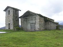
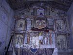
Chiliquín is one of 21 Peruvian districts that form the Province of Chachapoyas in the Amazon region. Chiliquin is located in the high mountain. Chiliquin offers several attractive places for tourists like ruins and cataracts. There is a church in the center of the village. There is no highway connection to the village.
The anniversary of the foundation of the district is celebrated on May 3. As the purtumute knows typical meals and you swallow them cooked between others.
Chiliquin shares its border with the District of Asunción (Chachapoyas) to the north, with the District of Quinjalca (Chachapoyas) to the east, the District of Sonche (Chachapoyas) to the south, the District of Valera to the south-west, and the District of Jumbilla (Chachapoyas)to the west.
Bagua Bongará Chisquilla · Churuja · Corosha · Cuispes · Florida · Jazán · Jumbilla · Recta · San Carlos · Shipasbamba · Valera · YambrasbambaChachapoyas Asunción · Balsas · Chachapoyas · Cheto · Chiliquín · Chuquibamba · Granada · Huancas · La Jalca · Leimebamba · Levanto · Magdalena · Mariscal Castilla · Molinopampa · Montevideo · Olleros · Quinjalca · San Francisco de Daguas · San Isidro de Maino · Soloco · SoncheCondorcanqui Luya Camporredondo · Cocabamba · Colcamar · Conila · Inguilpata · Lámud · Longuita · Lonya Chico · Luya · Luya Viejo · María · Ocalli · Ocumal · Pisuquia · Providencia · San Cristóbal · San Francisco del Yeso · San Jerónimo · San Juan de Lopecancha · Santa Catalina · Santo Tomás · Tingo · TritaRodríguez de Mendoza Chirimoto · Cochamal · Huambo · Limabamba · Longar · Mariscal Benavides · Milpuc · Omia · San Nicolás · Santa Rosa · Totora · Vista AlegreUtcubamba
Categories:- Districts of the Amazonas Region
- Districts of the Chachapoyas Province
- Peru geography stubs
Wikimedia Foundation. 2010.


