- Mount Lamborn
-
Mount Lamborn 
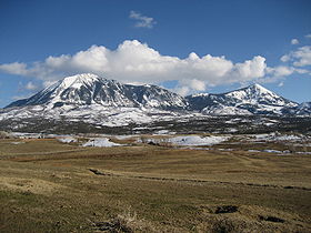
View of Mount Lamborn (left) and Landsend Peak (right) from Lamborn Mesa, near Paonia, ColoradoElevation 11,402 ft (3,475 m) NAVD 88[1] Prominence 1,596 ft (486 m) [2] Location Colorado Location Delta County, Colorado, USA Range West Elk Mountains, San Juan Mountains Coordinates 38°48′11″N 107°31′22″W / 38.80306°N 107.52278°WCoordinates: 38°48′11″N 107°31′22″W / 38.80306°N 107.52278°W[1] Topo map USGS Paonia Mount Lamborn is a peak in the West Elk Mountains of the US State of Colorado, located about 6 mi (10 km) southeast of the town of Paonia in the Gunnison National Forest. It is the highest point in Delta County[3]. Together with nearby Landsend Peak to the southwest, it lies at the western edge of the West Elks, rising dramatically 5,900 ft (1,800 m) above the valley of the North Fork Gunnison River to the west.
References
- ^ a b "Lamborn". NGS data sheet. U.S. National Geodetic Survey. http://www.ngs.noaa.gov/cgi-bin/ds_mark.prl?PidBox=JL0893. Retrieved 2011-03-03.
- ^ "Mount Lamborn, Colorado". Peakbagger.com. http://www.peakbagger.com/peak.aspx?pid=5716. Retrieved 2011-03-03.
- ^ Delta County summits on listsofjohn.com
External links
Categories:- Geography of Delta County, Colorado
- Mountains of Colorado
- Colorado geography stubs
Wikimedia Foundation. 2010.

