Downtown Lethbridge

Downtown Lethbridge
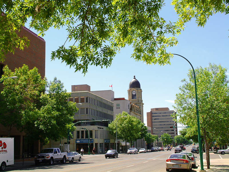
4 Avenue South facing west

Downtown Lethbridge is the commercial centre of Lethbridge, Alberta, hosting most of the city's banks and several accounting and law practices, including national firms.

Contents

Boundaries

Downtown Lethbridge is located in Lethbridge<div style="position: absolute; z-index: 2; top: Expression error: Missing operand for *%; left: 55612.1%; height: 0; width: 0; margin: 0; padding: 0;">
{{{alt}}}
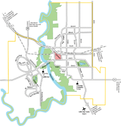
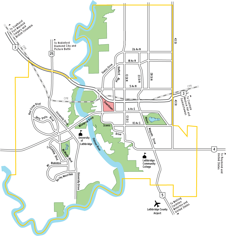
Location of downtown marked in red

Strictly speaking, the downtown is defined by the Oldman River valley on the west, the Crowsnest Highway and the CPR rail line on the north, Stafford Drive (9 Street) on the east and 6 Avenue on the south. It is not very large and contains very little in neighbourhood structure. It is, home to Chinatown, a two block area on 2 Avenue, west of Galt Gardens.

Transportation

Downtown Lethbridge serves as a transportation hub. Whoop-up Drive, the busiest roadway in Lethbridge, connects to downtown. Scenic Drive also provides downtown with a connection to the United States via Highway 4 and the Lethbridge County Airport via Highway 5. Downtown has two connections to the Crowsnest Highway, which provides direct access to British Columbia and indirect access to Calgary and Saskatchewan. The city's only Greyhound terminal is located downtown. The city's main transit terminal is downtown; half of the city's bus routes converge on 4 Avenue.

Arts and culture

Arts and culture venues in Lethbridge are located in or near downtown. There are two art galleries (Southern Alberta Art Gallery and Bowman Arts Centre), two theatres (Yates Theatre and Sterndale Bennet Theatre), the Galt Museum, two cinemas, the Lethbridge Public Library and several nightclubs.

Shopping

The downtown area has several hundred street-front retail stores interspersed with professional services. Two of the city's largest malls (Lethbridge Centre and Park Place Mall) are located downtown.

Housing

Much of the land use in the downtown area is commercial or public use. Residential use is generally of three different types: high density apartments (over a dozen stories), medium-density apartments (two-storey buildings and units above retail establishments) and condominiums for seniors. There are three senior care facilities in or near downtown.

See also

External links

Coordinates: 49°41′42″N 112°50′20″W / 49.695°N 112.839°W / 49.695; -112.839


Wikimedia Foundation. 2010.

Игры ⚽ Поможем написать курсовую

Look at other dictionaries:

  • Lethbridge — Infobox Settlement native name = official name = City of Lethbridge nickname = imagesize = image caption = Downtown Lethbridge as seen on 4 Avenue south facing west flag size = 125px image shield = Lethbridge coat.png shield size =125px image dot …   Wikipedia

  • Lethbridge Collegiate Institute — Infobox Education in Canada name=Lethbridge Collegiate Institute imagesize=300px motto=Pro Scola et Pro PatriaCref|a motto translation=For School and For Country streetaddress=1701 5 Avenue SouthCref|b city=Lethbridge province=Alberta… …   Wikipedia

  • Lethbridge Centre — infobox shopping mall shopping mall name = Lethbridge Centre location = Lethbridge, Alberta, Canada opening date = 1975 developer= Poole Construction manager= owner= Lethbridge Centre Inc. number of anchors = 1 (major) floors= 2 floor area =… …   Wikipedia

  • Lethbridge County Airport — Infobox Airport name = Lethbridge Airport IATA = YQL ICAO = CYQL type = Public owner = operator = County of Lethbridge city served = location = Lethbridge elevation f = 3,048 elevation m = 929 coordinates = website =… …   Wikipedia

  • Lethbridge Transit — Infobox Bus transit name = logo size = 250 image size = image caption = company slogan = Wherever Life Takes You parent = founded = 1912 headquarters = 619 4 Avenue North locale = Lethbridge, Alberta service area = service type = Public transit… …   Wikipedia

  • Lethbridge Regional Police Service — Infobox Police Department name = Lethbridge Regional Police Service logo = motto = established = 1 February,2004 jurisdiction = Regional sworn = 141 non sworn = 43 stations = 1 chief = Tom McKenzie website =… …   Wikipedia

  • Lethbridge Public Library — The Lethbridge Public Library is a public library service that is provided by the municipality of Lethbridge, Alberta, Canada. It was established in 1919. While it has had as many as three branches at one time, the library currently has a single… …   Wikipedia

  • Downtown Edmonton — Coordinates: 53°32′25″N 113°29′54″W / 53.54028°N 113.49833°W / 53.54028; 113.49833 Downtown Edmonton …   Wikipedia

  • List of neighbourhoods in Lethbridge — The city of Lethbridge, Alberta, Canada has over 30 neighbourhoods.DowntownDowntown Lethbridge strictly speaking is bordered by the Oldman River valley on the west, the Crowsnest Highway and the CPR rail line on the north, Stafford Drive (9… …   Wikipedia

  • Transportation in Lethbridge — There are many forms of transportation in Lethbridge, Alberta, including highways and public transit. Lethbridge s airport is Lethbridge County Airport (YQL), which is a short drive south of the city boundary. Lethbridge also has an intricate… …   Wikipedia

Share the article and excerpts

Direct link
Do a right-click on the link above
and select “Copy Link”