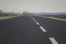
Christmas Valley Airport

Christmas Valley Airport
Cvairport.jpg
IATA: noneICAO: 62SFAA LID: 62S
Summary
Airport type Public
Operator Christmas Valley Parks & Recreation
Location Christmas Valley, Oregon
Elevation AMSL 4,317 ft / 1,316 m
Coordinates 43°14′12″N 120°39′58″W / 43.23667°N 120.66611°W / 43.23667; -120.66611Coordinates: 43°14′12″N 120°39′58″W / 43.23667°N 120.66611°W / 43.23667; -120.66611
Runways
Direction Length Surface
ft m
7/25 5,200 1,585 Asphalt

Christmas Valley Airport (FAA LID: 62S) located 1 m (2 km) southeast of Christmas Valley, Oregon. The airport consists of a 60' (18m) wide runway with a segmented circle marked by white tires and a medium-intensity runway lighting system which allows 25 minutes for landing once an aircraft is on beam and activates the system. Pilot activates the Runway Edge Lights: RY 7/25 - Common Traffic Advisory Frequency (CTAF). Tie-downs are available but at this time there are no fuel or oxygen services onsite. Two single engine aircraft are based on the field. The airstrip is unattended and open for public use.

History

Established in 1962, the airport was intended to promote land development.[1] The runway was built as part of the original development of the town and dedicated in 1985. A recent $500,000 grant from the Federal Aviation Administration widened, paved, and lit the mile-long airstrip.

References

External links


Wikimedia Foundation. 2010.

Игры ⚽ Поможем написать курсовую

Look at other dictionaries:

  • Christmas Valley, Oregon — Christmas Valley is an unincorporated community in Lake County, Oregon, United States. The community was named after nearby dry Christma(n)s Lake, east of the present townsite and the site of the former Lake post office, which ran from 1906 until …   Wikipedia

  • Valley Parade — Full name Coral Windows Stadium Location Bradford, West Yorkshire, England …   Wikipedia

  • Robin Hood Airport Doncaster Sheffield — Doncaster Sheffield Airport IATA …   Wikipedia

  • Table Rock Airport — is a private Airport located 8 miles west of Christmas Valley in Lake County, Oregon, USA.External links …   Wikipedia

  • List of Christmas films — Christmas or Christmas Day is a holiday[1][2][3] generally observed on December 25 (with alternative days of January 6, 7 and 19[4]) to commemorate the birth of Jesus, the central figure of Christianity.[5] …   Wikipedia

  • Seattle-Tacoma International Airport — Infobox Airport name = Seattle Tacoma International Airport nativename = Sea Tac Airport caption = Main terminal with views of the runways at SeaTac IATA = SEA ICAO = KSEA FAA = SEA type = Public owner = operator = Port of Seattle city served =… …   Wikipedia

  • Los Angeles International Airport — LAX redirects here. For other uses, see LAX (disambiguation). See also: List of airports in the Los Angeles area Los Angeles International Airport …   Wikipedia

  • Sun Valley, Idaho — Infobox Settlement official name = Sun Valley, Idaho other name = native name = nickname = settlement type = City motto = imagesize = image caption = flag size = image seal size = image shield = shield size = image blank emblem = blank emblem… …   Wikipedia

  • Salt Lake City International Airport — Infobox Airport name = Salt Lake City International Airport IATA = SLC ICAO = KSLC FAA = SLC type = Public owner = Salt Lake City operator = city served = Salt Lake City, Utah location = elevation f = 4,227 elevation m = 1,288 coordinates =… …   Wikipedia

  • Pre-Christmas 2004 snowstorm — Infobox winter storm|name=Pre Christmas 2004 Snowstorm image location=2004122306GOES12ir.jpg stormtype=Winter storm date formed=December 21, 2004 date dissipated=December 24, 2004 maximum amount=29 inches (73.7 cm) pressure=994 mbar (hPa) total… …   Wikipedia

Share the article and excerpts

Direct link
Do a right-click on the link above
and select “Copy Link”