Orovnica — (Village) Administration Pays Slovaquie … Wikipédia en Français
Banská Bystrica Region — Geobox | Region name = Banská Bystrica other name = category = Region image caption = image caption = symbol = symbol type = Coat of arms etymology = official name = motto = nickname = country = Slovakia country state = region = district =… … Wikipedia
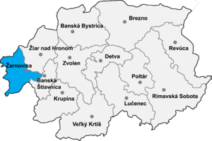
Žarnovica District — Infobox Slovak district subject name = Žarnovica District region district slovak region = Banská Bystrica Region population = 27,634 (2001) prefix = ? area = 426 car plate = ZC image location = Okres zarnovica.png Žarnovica District ( okres… … Wikipedia
Malá Lehota — Žarnovica District in the Banská Bystrica region Malá Lehota is a village and municipality in the Žarnovica District, Banská Bystrica Region in Slovakia … Wikipedia
Ostrý Grúň — Žarnovica District in the Banská Bystrica region Ostrý Grúň is a village and municipality in the Žarnovica District, Banská Bystrica Region in Slovakia … Wikipedia
Nová Baňa — Coordinates: 48°25′28″N 18°38′21″E / 48.42444°N 18.63917°E / 48.42444; 18.63917 … Wikipedia
List of municipalities and towns in Slovakia — Slovakia This is a comprehensive list of municipalities and towns in Slovakia. For lists of towns and municipalities sorted by Regions see the individual articles on Regions. For an outdated list of towns only in Slovakia see also List of towns… … Wikipedia
Hodrusa-Hamre — Hodruša Hámre Wappen Karte … Deutsch Wikipedia
Hodruša-Hámre — Wappen Karte … Deutsch Wikipedia
Hronsky Benadik — Hronský Beňadik Wappen Karte … Deutsch Wikipedia
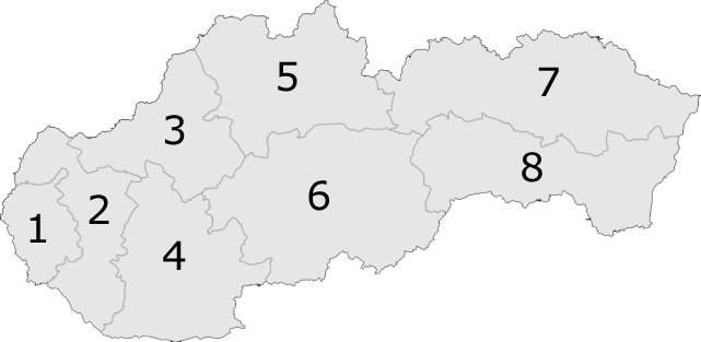
 6: Banská Bystrica Region
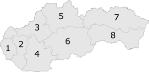
 Categories: