- County Borough of Warley
-
Warley Motto: Unity and Progress 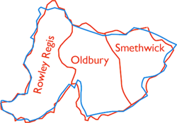
Geography Status County borough, Civil parish 1966 area 3,833 acres (15.51 km2) 1974 area 3,833 acres (15.51 km2) HQ Council House, Smethwick History Created 1966 Abolished 1974 Succeeded by Sandwell Demography 1971 population 163,545 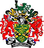
Warley was a county borough and civil parish forming part of the West Midlands conurbation, England, and geographical county of Worcestershire.[1] It was formed in 1966 by the combination of the existing county borough of Smethwick with the municipal boroughs of Oldbury and Rowley Regis (along with small sections of Birmingham, Dudley, Tipton, West Bromwich and Halesowen), by recommendation of the Local Government Commission for England.[1] It was abolished in 1974 under the Local Government Act 1972, with its area passing to the Metropolitan Borough of Sandwell.
Contents
Formation
See also: Worcestershire's evolving county boundariesThe Local Government Act 1958 appointed a Local Government Commission to review administrative structures and boundaries in England outside London. The Act designated a "West Midlands Special Review Area" as one of five conurbations in which urgent reform was felt to be needed.[2] The commission made its report in July 1961, recommending that the Black Country area of the West Midlands should be administered by five large county boroughs. The proposal to merge the boroughs of Oldbury, Rowley Regis and Smethwick as one of the new authorities was initially suggested by the three councils involved. The government announced that it accepted the proposals in November 1962, and it was originally intended that the County Borough of Warley should come into being on 1 April 1964.[3] The reforms were delayed when five district councils in the review area took legal action in an attempt to prevent their implementation. The legal process was finally concluded in the Court of Appeal in July 1965, with the court ruling in the government's favour.[3]
The Local Government (West Midlands) Order 1965 was made on 3 November 1965, with the changes to come into effect on 1 April 1966. The Order was debated in the House of Commons on 2 December 1965. John Horner, the Labour MP for Oldbury and Halesowen stated that while the boroughs of Oldbury and Rowley Regis had supported the creation of the new county borough in 1961, they no longer did so. In contrast, Peter Griffiths, Conservative member for Smethwick stated that the working party consisting of councillors for the three boroughs had given up their opposition, and were trying to make a success of the new county borough. The group did, however, have objections to boundary changes which caused the transfer of an estate of council houses to West Bromwich.[3]
The borough took its name from the ancient Manor of Warley, listed in the Domesday Survey as covering much of the area. This was subsequently divided into two parts: Warley Salop (in Shropshire) and Warley Wigorn (in Worcestershire). This was united as the civil parish of Warley in 1884, but later divided between the boroughs of Oldbury and Smethwick (Warley Woods).[1][4]
Smethwick and Rowley Regis had been part of Staffordshire, while Oldbury was part of Worcestershire (having been transferred from Shropshire in 1844). The new county borough was placed entirely in the geographical county of Worcestershire. The Oakham area of Dudley and Tividale area of Tipton were also incorporated into Warley.
Areas transferred
Existing local authority Area (acres) Population 1961 Notes Rowley Regis MB, Staffordshire 1,483 47,831 Remainder of borough was divided between West Bromwich CB (44 acres, pop 43)
and Halesowen MB (2 acres, pop 150)Oldbury MB, Worcestershire 1,231 51,902 Remainder of borough was divided between West Bromwich CB (11 acres, pop 43)
and Halesowen MB (95 acres, pop 2,003)Smethwick CB 988 67,501 Remainder of borough was divided between West Bromwich CB (20 acres, pop 889)
and Birmingham CB (3 acres, pop 0)Birmingham CB 50 1,820 Halesowen MB, Worcestershire 37 525 West Bromwich CB 32 169 Dudley CB 10 317 Tipton MB, Staffordshire 1 95 Borough was abolished, the remainder becoming part of West Bromwich CB Brierley Hill UD, Staffordshire 1 0 Urban District was abolished, most going to Dudley CB Source:Vision of Britain[5]
On creation, the county borough was included in the area of the West Midlands Constabulary, which was formed to cover the five Black Country county boroughs formed in 1966. Warley was included in the area of the West Midlands Passenger Transport Executive in 1969, and nominated one member of the transport authority.[6]
Borough council
The first elections to Warley Borough Council were in February 1966, with those elected being a "shadow council" until coming into full powers on 1 April.[3] The Labour Party initially held power, losing it to the Conservatives in 1968. Labour regained control in 1972 at the final borough election before abolition. The county borough was divided into fifteen wards, each returning three councillors and one alderman:[1]
- Abbey
- Bearwood
- Brandhall
- Bristnall
- Cradley Heath
- Langley
- Old Hill and Blackheath
- Rounds Green
- Rowley
- St Paul's
- Sandwell
- Soho
- Tividale
- Uplands
- Victoria
The political composition of the borough council was as follows following each election from 1967 to 1972:
Year Labour Conservative Liberal Independent 1967[7] 31 26 1 2 1968[8] 17 39 1 3 1969[9] 10 47 1 2 1970 [10] 17 41 1 0 1971[11] 26 32 1 1 1972[12] 39 21 0 0 Coat of arms
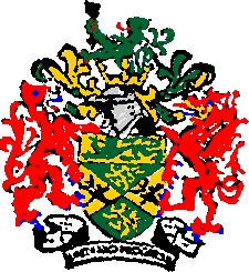
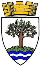
On 30 June 1966, the College of Arms granted the new county borough armorial bearings.[13] The design incorporated features from the arms of the three merged boroughs. The blazon of the arms was as follows:
Per saltire vert and or, two lions rampant in pale or, in fess of either flank a club in bend sinister surmounted by a caduceus in bend proper; on a chief or a lion passant vert. And for a crest: Issuant from a Saxon crown or, a demi lion rampant double queued vert holding with the dexter paw an arrow barb downwards proper. Supporters: on the dexter side a lion gules in the mouth an arrow proper; on the sinister side a dragon gules in the mouth an anchor or.[13]
The "chief" or upper third of the shield bearing a lion passant came from the arms of Rowley Regis, and the "per saltire" division of the arms and green and gold colouring was found in Oldbury's insignia. The gold lions on a green background were from the arms of the Robsart family, while the crossed club and caduceus were the arms of James Watt. The crest featured a Saxon crown from which rose a green double-tailed lion, emblem of the Suttons, mediaeval lords of Dudley. The lion held an arrow from tha arms of Matthew Boulton. The supporters of the arms were a red lion and dragon. The lion was from the armorial bearings of Sir James Timmins Chance, while the dragon was intended to represent the ancient Britons, founders of the "old burh" or Oldbury. Both animals held objects in their mouths as heraldic differences: an arrow (as in the crest) and an anchor (for Cradley Heath's traditional industry). The motto chosen by the borough was "Unity and Progress".[14]
Parliamentary constituencies
The Parliamentary Constituencies (England) Order 1970 divided the county borough into two parliamentary constituencies: Warley East and Warley West.[15] The constituencies were first used at the 1974 general election, shortly before the abolition of the borough. They were abolished in 1997, although the borough's name lives on in the modern Warley constituency which consists of Oldbury and Smethwick (formerly Warley East). The old Warley West seat was divided between the new constituency of Halesowen and Rowley Regis and an expanded West Bromwich West.
Abolition
On the formation of the West Midlands metropolitan county in 1974, the county borough of Warley merged with the county borough of West Bromwich to form the Metropolitan Borough of Sandwell.
References
- ^ a b c d Frederic A. Youngs, Jr., Guide to the Local Administrative Units of England, Vol.II: Northern England, London, 1991
- ^ Local Government Act 1958 c.55
- ^ a b c d "Local Government (West Midlands Order) HC Deb 02 December 1965 vol 721 cc1793-846.". Hansard 1804 - 2004. 1965-12-02. http://hansard.millbanksystems.com/commons/1965/dec/02/local-government-west-midlands-order#S5CV0721P0-04872. Retrieved 2008-06-03.
- ^ "Manors: Halesowen: Introduction, borough and manors in A History of the County of Worcester, Vol.3". British History Online. 1913. http://www.british-history.ac.uk/report.aspx?compid=43100#s3. Retrieved 2008-06-03.
- ^ "Warley County Borough". Vision of Britain. http://www.visionofbritain.org.uk/unit_page.jsp?u_id=10206236&c_id=10001043. Retrieved 2008-06-04.
- ^ The West Midlands Passenger Transport Area (Designation) Order 1969 (S.I. 1969 No. 97)
- ^ The Times, May 12, 1967
- ^ The Times, May 10, 1968
- ^ The Times, May 12, 1969
- ^ The Times, May 8, 1970
- ^ The Times, May 14, 1971
- ^ The Times, May 5, 1972
- ^ a b Geoffrey Briggs, Civic & Corporate Heraldry: A dictionary of impersonal arms of England, Wales and Northern Ireland, London, 1971
- ^ Peter Skidmore, The Civic Heraldry of the Black Country, Kingswinford, 2003
- ^ The Parliamentary Constituencies (England) Order 1970 (S.I. 1970 No. 1674)
External links
- Vision of Britain - Warley County Borough
Coordinates: 52°30′N 2°00′W / 52.5°N 2.0°W
 History of local government districts in Worcestershire
Ancient boroughs Alvechurch • Bewdley • Broadway • Clifton-upon-Teme • Droitwich • Dudley • Evesham • Halesowen • Kidderminster • Oldbury • Pershore • Tenbury • Worcester
Incorporated boroughs Bewdley • Droitwich • Dudley • Evesham • Halesowen • Kidderminster • Oldbury • Stourbridge • Warley • WorcesterUrban districts Bromsgrove • Halesowen • King's Norton and Northfield • Lye and Wollenscote • Malvern • North Bromsgrove • Redditch • Stourbridge • Stourport-on-SevernRural districts Bromsgrove • Droitwich • Evesham • Feckenham • Halesowen • Kidderminster • King's Norton • Martley • Pershore • Rock • Shipston-on-Stour • Tenbury • Upton upon Severn • YardleyCivil parishes Boundary changes affecting Worcestershire Categories:- History of Worcestershire
- History of Staffordshire
- History of the West Midlands (county)
- Local government in Worcestershire
- Local government in the West Midlands (county)
- Districts of England abolished by the Local Government Act 1972
- Sandwell
- County boroughs of England

Wikimedia Foundation. 2010.