Georgia State Route 66

Georgia State Route 66

Infobox_road
state=GA
type=
route=66
alternate_name=


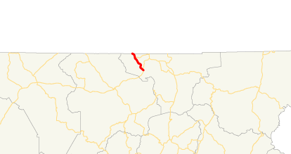
length_mi=4.75 [http://www.dot.state.ga.us/DOT/plan-prog/transportation_data/400reports/2002/dpp444_2002.pdf]
length_km=7.65
direction_a=North
starting_terminus=North Carolina state line
junction=
direction_b=South
ending_terminus=
established=
previous_route=65
next_route=69

State Route 66 is a 4.75-mile-long highway in Towns County in extreme northern Georgia, extending from U.S. 76/S.R. 2/S.R. 515 in Young Harris to the North Carolina state line. It then continues as a secondary state road to the unincorporated community of Warne, NC. The highway intersects one other route, S.R. 339, which is locally known as Crooked Creek Road.

S.R. 66 originally existed in two sections north and south of the state's highest peak, Brasstown Bald. The southern route provided access to the top of the mountain, while the northern portion was only accessible by a long-closed wagon road built in the 1950s. A projected highway was planned to replace the wagon road, but the project was canceled in 1982 when the area around it was designated a wilderness area. When the southern completion of S.R. 66 was canceled, S.R. 180 was extended along the connecting part and the remainder became S.R. 180 Spur. The former wagon road is still in use as a trail (Wagon Train Trail).

External links

* [http://psr.southeastroads.com/ga180_profile.htm Peach State Roads page on Georgia S.R. 180, including history of former southern portion of S.R. 66]
* [http://local.live.com/default.aspx?v=2&cp=34.952016~-83.85993&style=h&lvl=13&scene=1915478 Local.live.com aerial view of Georgia S.R. 66]


Wikimedia Foundation. 2010.

Игры ⚽ Нужно решить контрольную?

Look at other dictionaries:

  • Georgia State Route 75 — Karte …   Deutsch Wikipedia

  • Georgia State Route 21 — Infobox road state=GA type= route=21 length mi=84.29 length ref= [http://www.dot.state.ga.us/DOT/plan prog/transportation data/400reports/2002/dpp444 2002.pdf] length round=2 established= direction a=South direction b=North starting terminus=… …   Wikipedia

  • Georgia State Route 12 — GA 12 redirects here. For the congressional district, see Georgia s 12th congressional district. State Route 12 …   Wikipedia

  • Georgia State Route 27 — Infobox road state=GA type= route=27 length mi= length ref= [http://www.dot.state.ga.us/DOT/plan prog/transportation data/400reports/2002/dpp444 2002.pdf] length round=2 established= direction a=West direction b=East starting terminus= junction=… …   Wikipedia

  • Georgia State Route 55 — Infobox road state=GA type= route=55 length mi=20.56 length ref= [http://www.dot.state.ga.us/DOT/plan prog/transportation data/400reports/2002/dpp444 2002.pdf] length round=2 established= direction a=South direction b=North starting terminus=… …   Wikipedia

  • Georgia State Route 35 — Infobox road state=GA type= route=35 length mi= length ref= [http://www.dot.state.ga.us/DOT/plan prog/transportation data/400reports/2002/dpp444 2002.pdf] length round=2 established= direction a=South direction b=North starting terminus= junction …   Wikipedia

  • Georgia State Route 22 — Infobox road state=GA type= route=22 length mi= length ref= [http://www.dot.state.ga.us/DOT/plan prog/transportation data/400reports/2002/dpp444 2002.pdf] length round=2 established= direction a=West direction b=East starting terminus=Alabama… …   Wikipedia

  • Georgia State Route 56 — Infobox road state=GA type= route=56 length mi= length ref= [http://www.dot.state.ga.us/DOT/plan prog/transportation data/400reports/2002/dpp444 2002.pdf] length round=2 established= direction a=South direction b=North starting terminus= junction …   Wikipedia

  • Georgia State Route 24 — Infobox road state=GA type= route=24 length mi= length ref=Fact|date=April 2007 length round=0 established= direction a=South direction b=North starting terminus= junction= ending terminus= previous route=23 next route=25State Route 24 is a state …   Wikipedia

  • Georgia State Route 37 — Infobox road state=GA type= route=37 length mi= length ref= [http://www.dot.state.ga.us/DOT/plan prog/transportation data/400reports/2002/dpp444 2002.pdf] length round=2 established= direction a=West direction b=East starting terminus= junction=… …   Wikipedia

  • Georgia State Route 48 — Infobox road state=GA type= route=48 length mi=12.52 length ref= [http://www.dot.state.ga.us/DOT/plan prog/transportation data/400reports/2002/dpp444 2002.pdf] length round=2 established= direction a=West direction b=East starting terminus=… …   Wikipedia

Share the article and excerpts

Direct link
Do a right-click on the link above
and select “Copy Link”