Orávka — (Village) Administration Pays Slovaquie … Wikipédia en Français
Liste der Städte und Gemeinden in der Slowakei/M-R — Übersicht M bis R Teil 1 A bis G Teil 2 H bis Ľ Teil 3 M bis R Teil 4 S bis Ž Übersicht M N Ň O P R M Städte und Gemeinden in der Slowakei … Deutsch Wikipedia
Liste der Städte und Gemeinden in der Slowakei Teil 3 — Übersicht M bis R Teil 1 A bis G Teil 2 H bis Ľ Teil 3 M bis R Teil 4 S bis Ž Übersicht M N Ň O P R M Städte und Gemeinden in der Slowakei … Deutsch Wikipedia
List of chicken breeds — Thirty types of known chickens There are hundreds of chicken breeds in existence.[1] Domesticated for thousands of years, distinguishable breeds of chicken have been present since the combined factors of geographical isolation and selection for… … Wikipedia
Banská Bystrica Region — Geobox | Region name = Banská Bystrica other name = category = Region image caption = image caption = symbol = symbol type = Coat of arms etymology = official name = motto = nickname = country = Slovakia country state = region = district =… … Wikipedia
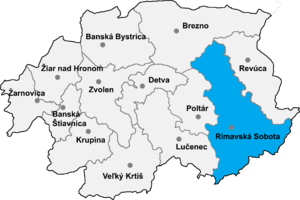
Rimavská Sobota District — District Country Slovakia Re … Wikipedia
Čerenčany — Rimavska Sobota District in the Banská Bystrica region Čerenčany (earlier Cšerencšány, is a village and municipality in the Rimavská Sobota District of the Banská Bystrica Region of southern Slovakia. During the past years village recorded… … Wikipedia
Čierny Potok — Rimavska Sobota District in the Banská Bystrica region Čierny Potok is a village and municipality in the Rimavská Sobota District of the Banská Bystrica Region of southern Slovakia. History It arose in 1955 by separation from Hodejov. During… … Wikipedia
Číž — Ciz redirects here. For the footballer, see Diego Ciz. Coordinates: 48°19′N 20°17′E / 48.317°N 20.283°E / 48.317; 20.28 … Wikipedia
Dolné Zahorany — Rimavska Sobota District in the Banská Bystrica region Dolné Zahorany (earlier Maďarské Záhorany; Hungarian: Hegymeg, earlier Magyarhegymeg) is a village and municipality in the Rimavská Sobota District of the Banská Bystrica Region of Slovakia.… … Wikipedia

