- Molveno
-
Molveno — Comune — Comune di Molveno Molveno and its lake.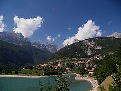 Location of Molveno in Italy
 Molveno
Coordinates: 46°9′N 10°58′E / 46.15°N 10.967°ECoordinates: 46°9′N 10°58′E / 46.15°N 10.967°E Country Italy Region Trentino-Alto Adige/Südtirol Province Trentino (TN) Government - Mayor Paolo Nicolussi Area - Total 35.2 km2 (13.6 sq mi) Elevation 864 m (2,835 ft) Population (31 August 2007)[1] - Total 1,125 - Density 32/km2 (82.8/sq mi) Demonym Molvenesi Time zone CET (UTC+1) - Summer (DST) CEST (UTC+2) Postal code 38018 Dialing code 0461 Patron saint St. Charles Borromeo Saint day November 4 Website Official website Molveno (German: Malfein) is a comune (municipality) in Trentino in the northern Italian region Trentino-Alto Adige/Südtirol, located about 15 km northwest of Trento. Molveno is sited at the northern end of a 4 km long lake (Lago di Molveno), at the feet of the Brenta Group and the Paganella mountain.
The Lake of Molveno, formed by an avalanche some 4,000 years ago, is the second largest in Trentino/Südtirol (3.3 km²). It has a maximum depth of 123 m.
Molveno borders the following municipalities: Andalo, Cavedago, Ragoli, San Lorenzo in Banale, Spormaggiore, Terlago, Tuenno and Vezzano.
History
The area of Molveno is known to have been settled since the Neolithic age. Due to its strategic position at the entrance of the Brenta-Paganella plateau, it was contended between the Bishops of Trento, the counts of Tyrol and the counts of Flavon.
From 1802 to 1805 the Austrians had a series of fortification built on the lake to halt the French troops.
References
External links
- Homepage of the city (Italian)
- Tourist website
Categories:- Municipalities of Trentino
- Cities and towns in Trentino-Alto Adige/Südtirol
- Trentino-Alto Adige/Südtirol geography stubs


Wikimedia Foundation. 2010.