Tay Valley, Ontario

Tay Valley, Ontario
Township of Tay Valley
—  Township  —
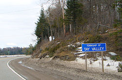
Road sign along Hwy. 7
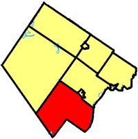
Tay Valley within Lanark County.
Coordinates: 44°52′N 76°23′W / 44.867°N 76.383°W / 44.867; -76.383Coordinates: 44°52′N 76°23′W / 44.867°N 76.383°W / 44.867; -76.383
Country  Canada
Province  Ontario
County Lanark
Incorporated January 1, 1998
Government
 - Type Township
 - Reeve Keith Kerr
 - Gov. Body Tay Valley Township Council
 - Federal riding Lanark—Frontenac—Lennox and Addington
 - Prov. riding Lanark—Frontenac—Lennox and Addington
Area
 - Land 527.46 km2 (203.7 sq mi)
Population (2006)[1]
 - Total 5,634
 - Density 10.7/km2 (27.7/sq mi)
Time zone EST (UTC-5)
 - Summer (DST) EDT (UTC-4)
Postal code span
Area code(s) 613
Website www.tayvalleytwp.ca

Tay Valley is a township in eastern Ontario, Canada, on the Tay River in Lanark County.

Contents

History

The township was incorporated on January 1, 1998 by amalgamating the former townships of Bathurst, South Sherbrooke and North Burgess. It was originally known as the township of Bathurst Burgess Sherbrooke, but adopted the Tay Valley name as of July 30, 2002.

Communities

The township comprises the communities of Althorpe, Bathurst Station, Bells Corners, Bolingbroke, Bolingbroke Siding, Brooke, Christie Lake, DeWitts Corners, Elliot, Fallbrook, Feldspar, Glen Tay, Harper, Maberly, Playfairville, Pratt Corners, Scotch Line, Stanleyville and Wemyss.

Maberly

Demographics

Population:[1]

  • Population in 2006: 5634 (2001 to 2006 population change: 3.6 %)
  • Population in 2001: 5440
  • Population in 1996:
    • Bathurst Township: 3179
    • North Burgess Township: 1269
    • South Sherbrooke Township: 732
  • Population in 1991:
    • Bathurst Township: 2888
    • North Burgess Township: 1021
    • South Sherbrooke Township: 669

Total private dwellings, excluding seasonal cottages: 2086 (total: 3511)

Mother tongue:

  • English as first language: 94.5 %
  • French as first language: 3 %
  • English and French as first language: 0 %
  • Other as first language: 2.5 %

References

  1. ^ Statistics Canada: 1996, 2001, 2006 census


Wikimedia Foundation. 2010.

Игры ⚽ Поможем написать курсовую

Look at other dictionaries:

  • Tay River (Ontario) — The Tay River is a river in eastern Ontario which empties into the Rideau River.This river flows through downtown Perth. It is 95 km in length and drains an area of 800 km². A canal connects the river to the Rideau Canal system at Beveridge Bay… …   Wikipedia

  • Ontario municipal elections, 2006 — Municipal election signs in North Bay, Ontario. In the 2006 municipal elections in Ontario, voters in the province of Ontario, elected mayors, councillors, school board trustees and all other elected officials in all of Ontario s municipalities.… …   Wikipedia

  • List of census subdivisions in Ontario — The following is a list of census subdivisions in the Canadian province of Ontario. NOTOC A B C D E F G H I J K L M N O P Q R S T U V W X Y Z*Key **C = City **R = First Nations Reserve **S E = Indian Settlement **T = Town **TP = Township **UNO =… …   Wikipedia

  • Ontario New Democratic Party candidates, 2011 Ontario provincial election — The New Democratic Party of Ontario (Ontario NDP) is one of three major political parties in Ontario, Canada running in the Ontario general election, 2011. Riding Candidate s Name Notes Residence Occupation Votes % Rank Ajax Pickering Wiseman,… …   Wikipedia

  • Ontario Highway 27 — Highway 27 York Regional Road 27 Simcoe County Road 27 Route information Maintained by the Regional Municipality of York and the County of Simcoe …   Wikipedia

  • Ontario general election, 2011 (candidates) — Main article: Ontario general election, 2011 The 2011 Ontario general election took place on Thursday, October 6, 2011 to elect members of the Legislative Assembly of Ontario, Canada. Contents 1 Candidates by region 1.1 Ottawa 1.2 Eastern O …   Wikipedia

  • Ontario Highway 12 — Highway 12 Route information Length: 145.1 …   Wikipedia

  • Lanark County, Ontario — Infobox Settlement name = official name =Lanark County other name = native name = nickname = The Maple Syrup Capital of Ontario settlement type =County total type = motto = imagesize = image caption = flag size = image seal size = image shield =… …   Wikipedia

  • List of municipalities in Ontario — There are currently 444 municipalities in the province of Ontario.[1][2] In Ontario the term municipality refers to various forms of local government (including cities, counties, regional municipalities, towns, townships, villages, and… …   Wikipedia

  • Liste Des Municipalités De L'Ontario — Liste des cantons, municipalités, villages et villes de la province de l Ontario au Canada. (Certaines municipalités ont un nom bilingue) Sommaire : Haut A B C D E F G H I J K L M N O P Q R S T U …   Wikipédia en Français

Share the article and excerpts

Direct link
Do a right-click on the link above
and select “Copy Link”