- Misakubo, Shizuoka
-
Misakubo
水窪町Former municipality Since April 1, 2005 Currently part of Tenryū-ku, Hamamatsu
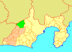
Misakubo's location in Shizuoka, Japan.Location Country Japan Region Chūbu region (Tōkai region) Prefecture Shizuoka District Iwata District, Physical characteristics Area 271.28 km² Population (as of April 1, 2005) Total 3,219 Density 11.86/km² Location 35°9′48″N 137°52′8″E / 35.16333°N 137.86889°E Symbols Tree Tochi-no-ki Flower Gold-banded Lily Bird Varied Tit Misakubo (水窪町 Misakubo-chō) was a town which was located in Iwata District, Shizuoka, Japan.
On July 1, 2005 Haruno, along with the town of Haruno, from Shūchi District, the towns of Hosoe, Inasa and Mikkabi, all from Inasa District, the town of Sakuma, the village of Tatsuyama, all from Iwata District, the towns of Maisaka and Yūtō, both from Hamana District, and the cities of Tenryū and Hamakita, was merged into the city of Hamamatsu, where it is now part of Tenryū-ku.
At the time of its merger, the town had an estimated population of 3,219 and a density of 11.86 persons per km². The total area was 271.28 km².
Misakubo is located on the Iida-sen (Iida Line) which runs from Toyohashi in Aichi Prefecture to Iida in Nagano Prefecture.
Festivals
Misakubo Matsuri (水窪まつり)
The most famous festival is the aptly named Misakubo Matsuri (Misakubo Festival) which takes place in mid-September. For more than a month prior to the two-day event the local people gather in area-groups and build a float, make costumes and practice skits. During the day of the festival the floats and performers travel round the town performing for the leaders of each area and the best performances are rewarded. The evenings are a traditional Yatai festival where wooden carved floats are pulled around the town by the revelers.
Kuni-Tori Tsunahiki (くにとり綱引き)
This is yearly tug-of-war competition between Misakubo, representing Shizuoka Prefecture and Nagano Prefecture. The winning team moves the border of the prefecture by 1 meter, expanding the winning prefecture. In 2006 Misakubo won but is currently 3 meters in the red.
Categories:- Dissolved municipalities of Shizuoka Prefecture
- Shizuoka geography stubs
Wikimedia Foundation. 2010.

