- Myrofyllo
-
Myrofyllo
ΜυρόφυλλοLocation 
 Myrofyllo
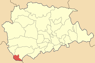
Coordinates 39°22′N 21°19′E / 39.367°N 21.317°ECoordinates: 39°22′N 21°19′E / 39.367°N 21.317°E Location within the peripheral unit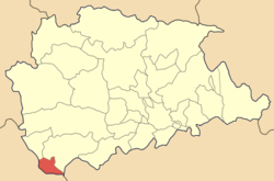
Government Country: Greece Region: Thessaly Regional unit: Trikala Municipality: Pyli Population statistics (as of 2001) Municipal unit - Population: 736 Other Time zone: EET/EEST (UTC+2/3) Auto: ΤΚ Myrofyllo (Greek: Μυρόφυλλο) is a village and a former community in the Trikala peripheral unit, Thessaly, Greece. Since the 2011 local government reform it is part of the municipality Pyli, of which it is a municipal unit.[1] Its population is 350 in the winter and 1000 in the summer.[2]
References
- ^ Kallikratis law Greece Ministry of Interior (Greek)
- ^ "Myrofyllo ( Myrokovo )". Municipality of Koziakas. http://www.dimoskoziaka.gr/diadromi_eg.asp?tpage=diadromi&diadromiID=10&merosID=13. Retrieved 2008-12-27.
Municipal unit of Aithikes Agios Nikolaos · Athamania · Desi · Drosochori · Elati · Gardiki · Kalogiroi · Neraidochori · Pertouli · Pyrra · VronteroMunicipal unit of Gomfoi Municipal unit of Myrofyllo MyrofylloMunicipal unit of Neraida Municipal unit of Pialeia Municipal unit of Pyli Municipal unit of Pynda Livadochori · Mesochora · Moschofyto · Nea Pefki · Paramero · Polyneri · Stournaraiika · Valkano · VathyrrevmaCategories:- Populated places in Trikala (peripheral unit)
- Thessaly geography stubs

Wikimedia Foundation. 2010.