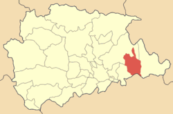
- Oichalia, Trikala
-
For other uses, see Oichalia (disambiguation).
Oichalia
ΟιχαλίαLocation Coordinates 39°36′N 21°59′E / 39.6°N 21.983°ECoordinates: 39°36′N 21°59′E / 39.6°N 21.983°E Government Country: Greece Region: Thessaly Regional unit: Trikala Municipality: Farkadona Population statistics (as of 2001) Municipal unit - Population: 5,783 Other Time zone: EET/EEST (UTC+2/3) Auto: ΤΚ Oichalia Greek: Οιχαλία) is a town and a former municipality in the Trikala peripheral unit, Thessaly, Greece. Since the 2011 local government reform it is part of the municipality Farkadona, of which it is a municipal unit.[1] Its 2001 population was 5,783, its town population was 2,936. Oichalia is located southwest of Elassona, west of Larissa, northwest of the city of Karditsa and east of the city of Trikala and is situated in the Thessalian Plain. Itwas formerly known as Neochori. Oichalia is connected with the GR-6 (Larissa - Trikala - Ioannina - Igoumenitsa).
Contents
Subdivisions
The municipal unit Oichalia is subdivided into the following communities:
- Georganades
- Klokotos
- Krini
- Oichalia
- Petroto
Population
Year Settlement population Municipality population 1981 3,221 - 1991 3,271 6,567 2001 2,936 5,783 After World War II and the Greek Civil War, the population steadily declined as residents moved to larger towns and cities and the richest countries in the world.
History
Electricity and automobiles arrived in the 1960s, it was linked with pavement in the late-20th century, television arrived in the 1980s. Internet and computers arrived in the late-1990s.
See also
External links
Northwest: Paliokastro North: Paliokastro West: Pellinaio Gomfoi East: Farkadona South: Karditsa Prefecture References
- ^ Kallikratis law Greece Ministry of Interior (Greek)
Municipal unit of Farkadona Municipal unit of Oichalia Municipal unit of Pelinnaioi Faneromeni · Nomi · Petroporos · Servota · TaxiarchesCategories:- Populated places in Trikala (peripheral unit)
Wikimedia Foundation. 2010.


