- Bird's Head Peninsula
-
"Bird's Head" redirects here. For tectonic plate, see Bird's Head Plate. For languages, see Bird's Head languages.
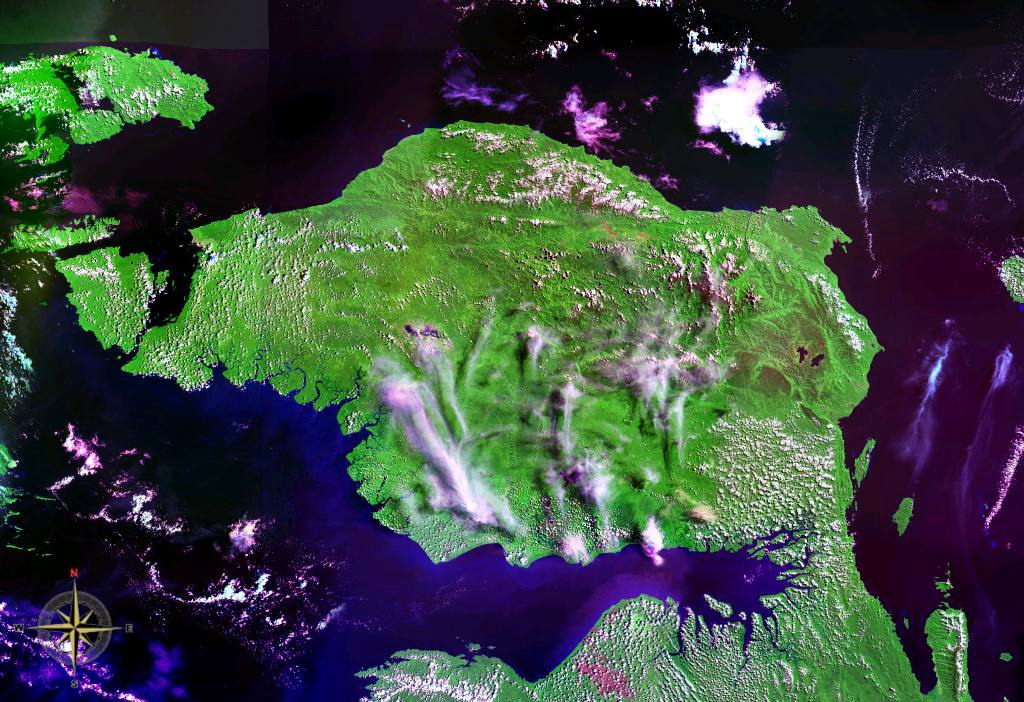
Bird's Head Peninsula (Kepala Burung) Doberai Peninsula Region 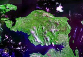 Bird's Head Peninsula seen from space (false color)
Country Indonesia Provinces West Papua Cities Manokwari, Sorong, Aimas, Bintuni, Teminabuan, Sausapor Highest point Pegunungan Arfak - location Arfak Mountains - elevation 2,920 m (9,580 ft) Lowest point - location Along coast Area 21,469 sq mi (55,604 km2) Population 402,126 (2010) Density 402,126 / km2 (1,041,502 / sq mi) Timezone EIT (UTC+9) ISO 3166-2 ID-IJ License Plate DS 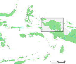
The Bird's Head (Indonesian: Kepala Burung, Dutch: Vogelkop) Peninsula or Doberai Peninsula is a large peninsula that makes up the northwest portion of the Province of West Papua, Indonesia.
Contents
Location and geography
The Bird's Head Peninsula forms the north-western end of the island of New Guinea. To the east is Cenderawasih Bay and to the south Bintuni Bay. To the west, across the Dampier Strait is Waigeo island of Raja Ampat, and Batanta island lies just off the northwest tip. The peninsula south is Bomberai Peninsula.
The peninsula is around 200 by 300 kilometres, and is bio-geographically diverse, containing coastal plains to the south. The Arfak Mountains are a 3000 metre high mountain range that are found in the east. Slightly shorter than the Arfak Mountains, the Tamrau Mountains are found in the north. Bon Irau, a 2420 meter high mountain, is found in the Tamrau Mountains and is the highest mountain. The highest mountain on the Bird's Head Peninsula is Pegunungan Arfak. It is 2920 meters (9582 feet) high and is located 24 miles southwest of Manokwari. [1]
Flora and fauna
The peninsula is covered by the Vogelkop Montane Rain Forests Ecoregion. It includes more than 22,000 km² of montane forests at elevations of 1,000 m and higher. Over 50% of these forests are located within protected areas. There are over 300 bird species on the peninsula, of which at least 20 are unique to the ecoregion, and some live only in very restricted areas. These include the Grey-banded Munia, Vogelkop Bowerbird, and the King Bird-of-paradise.[2]
Road construction, illegal logging, commercial agricultural expansion and ranching potentially threaten the integrity of the ecoregion.[2] The south-western coast of the peninsula forms part of the Teluk Cenderawasih National Park.[3]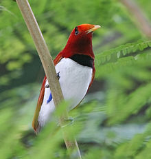 The King Bird-of-paradise is one of over 300 bird species on the peninsula.
Culture
Archaeological findings indicate that local settlement dates back at least 26,000 years BP.[1] Today, most people live in villages along the coast, with small concentrations inland. Villagers practise subsistence farming by shifting cultivation of copra, rice, corn and peanuts, as well as hunting.[2] There are more than 80 villages scattered around the peninsula. There are about 18 main settlements that are the principal town of one of the five regencies found on the peninsula. These cities include Bintuni, Teminabuan, Sorong, Aimas, and Manokwari. Although, the largest settlements are the city of Sorong on the west coast and Manokwari on the east coast. Manokwari is the largest city with as of 2010 a population of 135,000 and a metropolitan area of 155,000. The city of Sorong has a population of 125,000 and a metropolitan area of 170,000. This city also has the largest metropolitan area.
There are a large number of traditional languages spoken on the peninsula, classified as South Bird's Head languages, East Bird's Head languages, or West Papuan languages.
References
- ^ a b Flip van Helden: A bird’s eye view of the Bird’s Head Peninsula, in Irian Jaya Studies Programme for Interdisciplinary Research (IIAS) Newsletter nr.37, June 2005, retrieved 11 May 2010
- ^ a b c WWF: Bird wonders of New Guinea’s western-most province, retrieved 11 May 2010
- ^ Ministry of Forestry: Teluk Cenderawasih NP, retrieved 11 May 2010
Categories:- Peninsulas of Indonesia
- Western New Guinea
- West Papua


Wikimedia Foundation. 2010.