Sorong (city)

Sorong (city)
Sorong
Nuwar
—  City  —
Nickname(s): Cahaya Islam
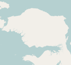
Sorong is located in Bird's Head Peninsula
Sorong
Location of the town in the Bird's Head Peninsula
Sorong is located in Indonesia
Sorong
Location of the town in Indonesia
Coordinates: 0°52′S 131°15′E / 0.867°S 131.25°E / -0.867; 131.25
Country  Indonesia
Province West Papua
Population
 – City 125,535
 – Metro 184,239
Time zone WIB (UTC+7)

Sorong is a chartered coastal city in the eastern Indonesian province of West Papua. Its only land borders are with Sorong Regency. It is the gateway to Indonesia's Raja Ampat Islands, species rich coral reef islands in an area considered the heart of the world's coral reef biodiversity. It also the logistics hub for Indonesia's thriving eastern oil and gas frontier. Sorong has experienced exponential growth in the last five years, and further growth is anticipated as Sorong becomes linked by road to other frontier towns in Papua's Bird's Head Peninsula. The city has a population of 125,535.

Container port

A container port will be built in Sorong with an annual container handling capacity of 500,000 twenty-foot equivalent units (TEUs) and cost Rp.800 billion ($93.6 million). Construction will be initilised at early 2012 and expect to finish in the middle of 2013.[1]

Sister Cities

References

Coordinates: 0°52′S 131°15′E / 0.867°S 131.25°E / -0.867; 131.25


Wikimedia Foundation. 2010.

Игры ⚽ Поможем написать реферат

Look at other dictionaries:

  • Sorong — may refer to:* Sorong (city) * Sorong Regency …   Wikipedia

  • Sorong Airport — Infobox Airport name = Sorong Airport nativename = IATA = SOQ ICAO = WASS type = owner = operator = city served = location = Sorong, West Papua, Indonesia elevation f = 10 elevation m = 3 coordinates =… …   Wikipedia

  • Sorong — Original name in latin Sorong Name in other language Kota Sorong, SOQ, Sorong, Соронг State code ID Continent/City Asia/Jayapura longitude 0.87956 latitude 131.26104 altitude 7 Population 125535 Date 2013 04 21 …   Cities with a population over 1000 database

  • Jembrana City International Airport — Bandar Udara Internasional Kota Jembrana IATA: none – ICAO: none Summary Runways Direction Length …   Wikipedia

  • West Papua (Indonesian province) — Infobox Provinces of Indonesia name = West Papua country=Indonesia logo= motto =Cintaku Negeriku capital=Manokwari population= area in km2=115364 Time=UTC+9 ethnicity = Melanesian religion =Christianity, Islam language = Indonesian (official)… …   Wikipedia

  • Manokwari — For the regency (kabupaten), see Manokwari Regency. Manokwari   City   Left top to bottom: Manokwari Skyline; Swiss Belhotel International;A cruise ship at Ma …   Wikipedia

  • Western New Guinea — Geobox Region name = Western New Guinea native name = other name = West Papua category = Region image size = image caption = country = Indonesia part type = Provinces part count = 2 part = Papua part1 = West Papua city = Jayapura city1 =… …   Wikipedia

  • List of regencies and cities of Indonesia — This article is part of the series Administrative divisions of Indonesia Province level Provinces City Regency level Cities Regencies …   Wikipedia

  • Bird's Head Peninsula — Bird s Head redirects here. For tectonic plate, see Bird s Head Plate. For languages, see Bird s Head languages. Bird s Head Peninsula (Kepala Burung) Doberai Peninsula Region …   Wikipedia

  • Sultan Hasanuddin International Airport — Bandar Udara Internasional Sultan Hasanuddin IATA: UPG – ICAO: WAAA …   Wikipedia

Share the article and excerpts

Direct link
Do a right-click on the link above
and select “Copy Link”