- Owmby by Spital
-
Coordinates: 53°22′29″N 0°29′49″W / 53.374680°N 0.496835°W
Owmby by Spital 
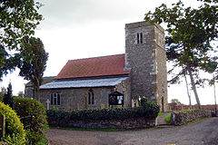
Owmby church
 Owmby by Spital shown within Lincolnshire
Population 309 (2001) OS grid reference TF001874 District West Lindsey Shire county Lincolnshire Region East Midlands Country England Sovereign state United Kingdom Postcode district LN8 Police Lincolnshire Fire Lincolnshire Ambulance East Midlands EU Parliament East Midlands UK Parliament Gainsborough List of places: UK • England • Lincolnshire Owmby by Spital is a village and civil parish in the West Lindsey district of Lincolnshire, England. According to the 2001 census the civil parish, known as Owmby, had a population of 309. It is 11 miles (18 km) north of Lincoln just off the A15 and it is 8 miles (13 km) west of Market Rasen. The parish covers an area of 1,600 acres (650 ha). Owmby is known as Owmby by Spital because of the hospital that used to be situated in the village.
It also has a neighbouring village called Normanby by Spital.
There is a church in the village dedicated to St. Peter and St. Paul. It was built in 1808 and it seats 200 people. However, parts of the structure date back to Norman times.[1]
There was a school built in 1836, but it was closed by 1881. Owmby by Spital was united with Normanby by Spital into a school board district on 18 January 1870. However, most children in the parish attended school in Normanby by Spital.
Contents
Notable residents
Bernie Taupin, the English lyricist famous for his collaboration with Elton John grew up in the village.
References
- ^ "Kellys Directory". Kellys Directories Ltd. p. 454. http://www.historicaldirectories.org/hd/d.asp. Retrieved 20 April 2011.
External links
External links
 Media related to Owmby by Spital at Wikimedia CommonsCategories:
- Villages in Lincolnshire
- Civil parishes in Lincolnshire
- West Lindsey
- Lincolnshire geography stubs
Wikimedia Foundation. 2010.

