- Chilean Central Valley
-
This article is about the valley between the Chilean Coast Range and the Andes. For the wine district, see Central Valley (wine region).
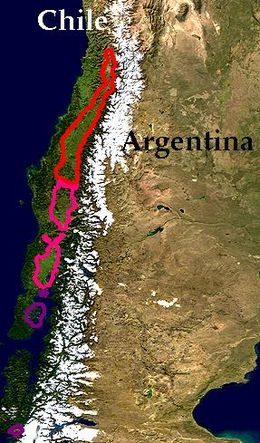
The Central Valley (Spanish: Valle Central), Intermediate Depression or Longitudinal Valley is the depression between the Chilean Costal Range and the Andes Mountains. The central valley should not be confused with Central Chile that encompasses part of the valley. At its broadest definition, the geological one, the Central Valley has a discontinuous extension from Pampa del Tamarugal at 20° S to Ofqui Isthmus at 46° S. The viticultural Central Valley extends from Santiago southwards to the Bío-Bío Region.
Sometimes Puerto Montt is considered the southern end of the Central Valley because south of there the valley is below sea level and emerges sporadically as islands down to the Ofqui Isthmus.
Geography and climate
The middle part of the Central valley (34° - 38 ° S) is a fertile region and the agricultural heartland of Chile. At these latitudes the Central Valley has a Mediterranean climate, with temperatures dropping and precipitation increasing in a regular pattern from north to south. Winters are mild and summers are usually moderately hot and dry.
Between the western foothills of the Andes and the eastern foothills of the Cordillera de la Costa lies a concave area known as the Depresión Intermedia or Valle Longitudinal (intermediate depression or longitudinal valley). This valley, which has been filled with the byproducts of volcanic activity and erosion of the surrounding mountains, was sculpted into its present smooth state by glaciers, both eolian and hydrous. It runs almost the entire length of Chile, from Arica to Puerto Montt, where it plunges into the sea at Reloncaví Sound.
The Depression is only interrupted in a small stretch between the south of the Atacama Region and northern Valparaíso, where the aforementioned foothills close in from both sides and become separated only by a few narrow river gorges called transverse valleys (valles transversales).
The annual mean temperatures in Santiago is 57°F (14°C) The temperate action of the ocean prevents temperatures from dropping drastically, and if snow falls in the area, it does not usually stay on the ground for more than a few hours.
In Santiago the annual rainfall is 13 inches and in Valparaíso, outside the valley in the coast at the same latitude, it amounts to 15 inches. Along the Central Valley rainfall increases gradually southward until it reaches 52 inches in Concepción.
External links
- An aerial Google view of the Chilean Central Valley. Argentina lies to the east of the Andes range
- Chilean National Tourism Service (Spanish)
- Chilean Meteorological Service (Spanish)
Geology of Chile Morphology 
Tectonics Antarctic Plate · Atacama Fault · Chile Rise · Chile Triple Junction · Easter Plate · Juan Fernández Ridge · Liquiñe-Ofqui Fault · Nazca Plate · Nazca Ridge · Peru-Chile Trench · Scotia Plate · South American PlateOrogenies Volcanism Regional geology Institutions Lists Categories:- Landforms of Chile
- Valleys of Chile
Wikimedia Foundation. 2010.

