- Otzberg
-
Otzberg 

 OtzbergLocation of Otzberg within Darmstadt-Dieburg district
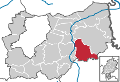

Coordinates 49°50′N 8°55′E / 49.83333°N 8.91667°ECoordinates: 49°50′N 8°55′E / 49.83333°N 8.91667°E Administration Country Germany State Hesse Admin. region Darmstadt District Darmstadt-Dieburg Local subdivisions 6 Ortsteile Mayor Karl Ohlemüller (CDU) Basic statistics Area 41.95 km2 (16.20 sq mi) Elevation 170-367 m Population 6,344 (31 December 2010)[1] - Density 151 /km2 (392 /sq mi) Other information Time zone CET/CEST (UTC+1/+2) Licence plate DA Postal code 64853 Area codes 06162, 06163 Website www.otzberg.de Otzberg is a municipality in the district of Darmstadt-Dieburg, located in the Odenwald. It was founded in 1972 by the merger of six former independent municipalities.
Otzberg consists of seven villages: Habitzheim, Hering, Lengfeld with Zipfen, Nieder-Klingen, Ober-Klingen and Ober-Nauses, and Schloss-Nauses.
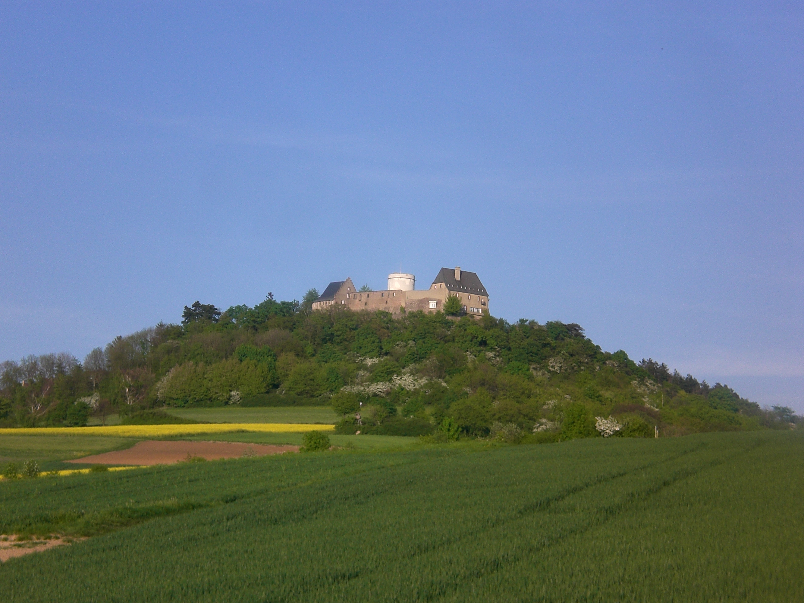
A showplace in Otzberg is the Veste Otzberg. This is an old fort, which was first mentioned in 1231. It is widely known for its white tower. The fort itself has been slowly reconstructed to resemble its medieval appearance.
Contents
Partner cities
 Lencloître, Département Vienne, France, since 1983
 Langenweißbach, Landkreis Zwickauer Land, Germany, since 1990
Geography
Location
The town is located in the northern Odenwald Otzberg in southern Hesse. The Otzberg, an extinct volcano, towers over 367 m above sea level. In clear conditions the eye can see from here to Frankfurt am Main and the Taunus.
Geology
The Otzberg is a residue around the volcano Böllsteiner gneiss, formed on an old fault zone (Otzberg column), which continues to the south and separates the eastern Böllsteiner, which is about 50 million years younger than western Bergsträßer Odw.
The Böllsteiner gneiss and basalt Otzberg caused by large movements of the earth's crust in two different geological eras [2]:
In the Palaeozoic (Paleozoic) walked the continental drift a southern continent to continent on a north.[3] This collided intervening dwarf-continent and in the Devonian and Carboniferous period (about 380-320 million years ago), the Variscan Mountains to the Odw counts delayed.[4] was already in the history of Böllsteiner gneiss. He emerged from granitic rocks, which have penetrated about 410 million years ago as molten rock from below into older sedimentary rocks. These were common - sunk into deeper areas of the earth's crust and converted there, at a high temperature pressure to schists and gneisses - a result of the co-thrusts. At the Otzberg column is welded these rocks - in the course of plate collision - with those of the Bergstrasse Odws.
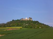 extinct volcano Otzberg and the old fort Veste Otzberg with the white tower
Many millions of years later, the mountain was already removed down to his torso and powerful Buntsandstein, Muschelkalk, Keuper and law [5] - deposits had altered the landscape, it came in Central Europe back to strong movements in the crust: In connection with a rift zone from the Mediterranean to the North Sea broke - in the Tertiary about 45 million years - the Upper Rhine Graben - and hence the Erbacher-Michelstädter ditch. To the subsidence in the Rhine-Main area also includes the Tire Bay. As a result, many cross dissected and transverse fractures in the area now Odenwald mountain blocks and ditches, so that magma could penetrate to the surface. Were formed in the central and northern Odw approximately 35-20 million years ago volcanoes such as the Otzberg. Some columns were filled with ore-bearing quartz and Schwerspatlösungen.
The Vulcan blankets are now - have been removed by erosion - as well as the Buntsandstein, Muschelkalk, Keuper and Jurassic - deposits. What is left is the basalt columns at Castle Hill - as remnants of the crater fill. The crystalline rock body was exposed again, Rivers cut a valley and then formed the present landscape.
Evidence of its geological past are relics of quarries and mines[6]:
- Basalt quarry on the stone pavement was collected on Otzberg (see basalt columns)
- Feldspar for the porcelain production: in Herring (1880)
- Schwerspatabbau (barite), east of Herring (1870)
- Iron ore mining is documented since 1472: reduction in Schwerspatgang for Zipf and Wiebelsbach (1850) and in quartz-iron-glance south corridors herring.
See also
References
- ^ "Die Bevölkerung der hessischen Gemeinden" (in German). Hessisches Statistisches Landesamt. 31 December 2010. http://www.statistik-hessen.de/static/publikationen/A/AI2_AII_AIII_AV_10-1hj_pdf.zip.
- ^ Eckardt Stein u.a : „Geologie des kristallinen Odenwalds – seine magmatische und metamorphe Entwicklung“. In: Jahresberichte und Mitteilungen, Oberrheinischer Geologischer Verein, N.F.83, S. 89-111, 2001
- ^ Wolfgang Franke: The mid-European segment of the Variscides: tectono-stratigraphic units, terrane boundaries and plate tectonic evolution. Geol.Soc.London Spec.Publ., 179, S. 35-61, 2000.
- ^ R. Altherr u.a.: Plutonism in the Variscan Odenwald (Germany): from subduction to collision. Int. J. Earth Sci. 88, S. 422-443, 1999.
- ^ G. Frenzel, G.: Die Nephelingesteinsparagenese des Katzenbuckels im Odenwald. Aufschluß Sonderband 27, 213-228, Heidelberg 1975.
- ^ Erwin Nickel: „Odenwald - Vorderer Odenwald zwischen Darmstadt und Heidelberg“. Sammlung geologischer Führer (2. Aufl.) 65, Borntraeger Berlin 1985.
External links
- Official Webpage of the Gemeinde Otzberg
- Museum Otzberg and castle Veste Otzberg
- Otzberg at the Open Directory Project
Alsbach-Hähnlein | Babenhausen | Bickenbach | Dieburg | Eppertshausen | Erzhausen | Fischbachtal | Griesheim | Groß-Bieberau | Groß-Umstadt | Groß-Zimmern | Messel | Modautal | Mühltal | Münster | Ober-Ramstadt | Otzberg | Pfungstadt | Reinheim | Roßdorf | Schaafheim | Seeheim-Jugenheim | Weiterstadt Categories:
- Municipalities in Hesse
- Darmstadt-Dieburg
- Electoral Palatinate
- Hesse geography stubs


Wikimedia Foundation. 2010.