- Clackmannan
-
Coordinates: 56°06′33″N 3°44′47″W / 56.109097°N 3.7465196°W
Clackmannan Scottish Gaelic: Clach Mhanainn[1] 
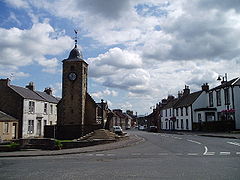
Clackmannan main street and Tollbooth
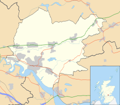
 Clackmannan shown within Clackmannanshire
Area 0.40 sq mi (1.0 km2) Population 3,348 [2] (2008 est.) - Density 8,370 /sq mi (3,230 /km2) OS grid reference NS911919 Council area Clackmannanshire Lieutenancy area Clackmannanshire Country Scotland Sovereign state United Kingdom Post town CLACKMANNAN Postcode district FK10 Dialling code 01259 Police Central Scotland Fire Central Scotland Ambulance Scottish EU Parliament Scotland UK Parliament Ochil and South Perthshire Scottish Parliament Ochil List of places: UK • Scotland • Clackmannan (Scottish Gaelic: Clach Mhanainn, meaning "Stone of Manau"), is a small town set in the Central Lowlands of Scotland. Situated within the Forth Valley, Clackmannan is 1.8 miles (2.9 km) south-east of Alloa and 3.2 miles (5.1 km) south of Tillicoultry. The town is part of the Clackmannanshire council area and was formerly the county town of the county of Clackmannan which is Scotland's smallest.
According to a 2009 estimate the population of the settlement of Clackmannan is 3,348 residents.[2]
Contents
History
The name of the town refers to the Stone of Mannan, a pre-Christian monument which can be seen in the town square, beside the Tollbooth Tower, which dates from the 16th century.
During the 12th century, the area formed part of the lands controlled by the abbots of Cambuskenneth. Later it became associated with the Bruce family. During the 14th century they built a strategic tower-house, which survives to this day above the town (Historic Scotland; can only be viewed from the outside due to subsidence).
See also
- List of places in Clackmannanshire
- Clackmannan (UK Parliament constituency)
- Clackmannan F.C. Former Scottish League members
References
- ^ Mac an Tàilleir, Iain (2003) Placenames.(pdf) Pàrlamaid na h-Alba. Retrieved 2011-05-29.
- ^ a b Population Breakdown by Settlement 2009, ClacksWeb Retrieved 2011-05-29.
External links
- Clackmannan Tower: Clackmannan Towers Official Website
- ClacksNet: Clackmannanshire's Community network
- Undiscovered Scotland: Clackmannan
- Look Aboot Ye - Clackmannanshire Community News, Information and Forums
- Clackmannan Town Hall Trust - Putting the heart back into our community
- Clackmannan Loyal - Horseshoe Bar Rangers Supporters Club
Towns and villages Alloa · Alva · Cambus · Clackmannan · Coalsnaughton · Devonside · Dollar · Fishcross · Forestmill · Glenochil · Inglewood · Kennet · Menstrie · Muckhart · Sauchie · Solsgirth · Tillicoultry · TullibodyCategories:- Central Scotland geography stubs
- Clackmannanshire
- Towns in Clackmannanshire
Wikimedia Foundation. 2010.

