- Niederried bei Interlaken
-
Niederried bei Interlaken 
Country Switzerland 
Canton Bern District Interlaken-Oberhasli 46°43′N 7°55′E / 46.717°N 7.917°ECoordinates: 46°43′N 7°55′E / 46.717°N 7.917°E Population 332 (Dec 2010)[1] - Density 49 /km2 (126 /sq mi) Area 4.29 km2 (1.66 sq mi)[2] Elevation 578 m (1,896 ft) Postal code 3853 SFOS number 0588 Mayor Hans Studer Surrounded by Habkern, Oberried am Brienzersee and Ringgenberg Website www.niederried-be.ch
SFSO statistics
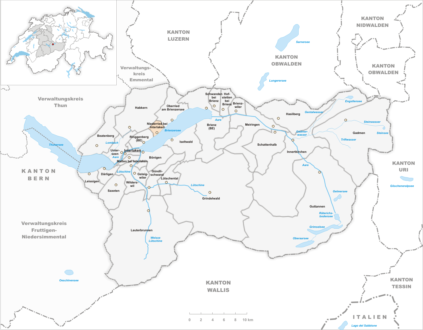
 Niederried bei InterlakenMap of Niederried bei Interlaken

Niederried bei Interlaken is a municipality in the Interlaken-Oberhasli administrative district in the canton of Bern in Switzerland.
Contents
History
Niederried bei Interlaken is first mentioned in 1291 as Riede.[3]
Origin of the name
The name means "lower Ried near Interlaken." There are two explanations for the origin of the name Ried: from the Old High German riod, reoth ("clearing") or the Swiss German Ried (land growing reeds and swampgrass).
Geography
Niederried bei Interlaken has an area, as of 2009[update], of 4.29 square kilometers (1.66 sq mi). Of this area, 0.92 km2 (0.36 sq mi) or 21.4% is used for agricultural purposes, while 2.36 km2 (0.91 sq mi) or 55.0% is forested. Of the rest of the land, 0.31 km2 (0.12 sq mi) or 7.2% is settled (buildings or roads), 0.02 km2 (4.9 acres) or 0.5% is either rivers or lakes and 0.68 km2 (0.26 sq mi) or 15.9% is unproductive land.[4]
Of the built up area, housing and buildings made up 4.9% and transportation infrastructure made up 2.3%. Out of the forested land, 50.6% of the total land area is heavily forested and 3.7% is covered with orchards or small clusters of trees. Of the agricultural land, 8.2% is pastures and 13.3% is used for alpine pastures. All the water in the municipality is in rivers and streams. Of the unproductive areas, 11.4% is unproductive vegetation and 4.4% is too rocky for vegetation.[4]
It lies in the Bernese Oberland on the north shore of Lake Brienz. The highest point is the Suggiture (2,085 m (6,841 ft)) at the northern edge of the municipality.
Demographics
Niederried bei Interlaken has a population (as of 31 December 2010) of 332.[1] As of 2007[update], 10.8% of the population was made up of foreign nationals. Over the last 10 years the population has decreased at a rate of -11.6%. Most of the population (as of 2000[update]) speaks German (92.4%), with Italian being second most common ( 2.9%) and Albanian being third ( 2.3%).
In the 2007 election the most popular party was the SVP which received 41.1% of the vote. The next three most popular parties were the FDP (17.9%), the SPS (11.7%) and the Green Party (9.9%).
The age distribution of the population (as of 2000[update]) is children and teenagers (0–19 years old) make up 25.4% of the population, while adults (20–64 years old) make up 58.5% and seniors (over 64 years old) make up 16.1%. In Niederried bei Interlaken about 67% of the population (between age 25-64) have completed either non-mandatory upper secondary education or additional higher education (either university or a Fachhochschule).
Niederried bei Interlaken has an unemployment rate of 2.07%. As of 2005[update], there were 13 people employed in the primary economic sector and about 4 businesses involved in this sector. 9 people are employed in the secondary sector and there are 3 businesses in this sector. 20 people are employed in the tertiary sector, with 8 businesses in this sector.[5] The historical population is given in the following table:[3]
year population 1764 107 1850 194 1900 181 1950 273 2000 342 References
- ^ a b Swiss Federal Statistical Office - STAT-TAB, online database – Datenwürfel für Thema 01.2 - Bevölkerungsstand und -bewegung (German) accessed 29 September
- ^ Arealstatistik Standard - Gemeindedaten nach 4 Hauptbereichen
- ^ a b Niederried bei Interlaken in German, French and Italian in the online Historical Dictionary of Switzerland.
- ^ a b Swiss Federal Statistical Office-Land Use Statistics 2009 data (German) accessed 25 March 2010
- ^ Swiss Federal Statistical Office accessed 01-Jul-2009
Beatenberg | Bönigen | Brienz (BE) | Brienzwiler | Därligen | Gadmen | Grindelwald | Gsteigwiler | Gündlischwand | Guttannen | Habkern | Hasliberg | Hofstetten bei Brienz | Innertkirchen | Interlaken | Iseltwald | Lauterbrunnen | Leissigen | Lütschental | Matten bei Interlaken | Meiringen | Niederried bei Interlaken | Oberried am Brienzersee | Ringgenberg | Saxeten | Schattenhalb | Schwanden bei Brienz | Unterseen | Wilderswil
Canton of Bern | Districts of Canton Bern | Municipalities of the canton of Bern
 Categories:
- Municipalities of Bern
- Municipalities of Switzerland


Wikimedia Foundation. 2010.