East Lexham

East Lexham

Coordinates: 52°43′12″N 0°45′09″E / 52.720019°N 0.752478°E / 52.720019; 0.752478

East Lexham
Lexham East-g3.jpg
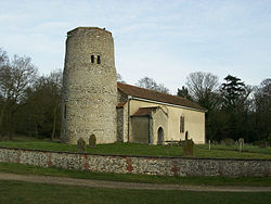
Saint Andrew parish church, East Lexham, Norfolk
East Lexham is located in Norfolk
East Lexham

 East Lexham shown within Norfolk
OS grid reference TF840120
    - London  106 miles (171 km) 
Parish Lexham CP
District Breckland
Shire county Norfolk
Region East
Country England
Sovereign state United Kingdom
Post town KING'S LYNN
Postcode district PE32
Dialling code 01328
Police Norfolk
Fire Norfolk
Ambulance East of England
EU Parliament East of England
List of places: UK • England • Norfolk

East Lexham is a village in the English county of Norfolk.[1] It is 7.7 miles (12.4 km) north of the town of Swaffham, 30.1 miles (48.4 km) west north west of Norwich and 106 miles (171 km) north east of London.

The village forms part of the civil parish of Lexham, which in turn is part of the district of Breckland. Local government responsibilities are shared between the parish, district and county councils.

The village is notable for its Anglican parish church. Dedicated to Saint Andrew, it is one of 124 existing round-tower churches in Norfolk.

The village lies about 1.5 miles (2.4 km) east of the A1065 Mildenhall to Fakenham road. The nearest railway station is at King’s Lynn for the Fen Line which runs between King’s Lynn and Cambridge. The nearest airport is Norwich International Airport.[2]

References

  1. ^ OS Explorer Map 238 – Dereham & Aylsham, Castle Acre & Reepham. ISBN 0-319-23810-5
  2. ^ County A to Z Atlas, Street & Road maps Norfolk, ISBN 978-1-84348-614-5

External links


Wikimedia Foundation. 2010.

Игры ⚽ Поможем решить контрольную работу

Look at other dictionaries:

  • West Lexham — Infobox UK place official name= West Lexham country= England region= East of England shire district= Breckland shire county= Norfolk civil parish= Lexham CP static static image caption =Saint Nicholas parish church, West Lexham, Norfolk… …   Wikipedia

  • List of places in Norfolk — This is a list of cities, towns and villages in the ceremonial and shire county of Norfolk, England. See the list of places in England for places in other counties. Contents Top 0–9 A B C D E F G H I J K L M N O P Q R S T U V W X Y Z NOTOC A*Acle …   Wikipedia

  • Mitford and Launditch — Hundred was an old grouping of parishes for administrative purposes in the County of Norfolk, England. It is located around East Dereham and is bordered by Walsingham Hundred, Aylsham Hundred, Horsham St. Faith Hundred, Forehoe Hundred, Wayland… …   Wikipedia

  • Round-tower church — Round tower churches are a type of church found mainly in England, almost solely in East Anglia; of about 185 surviving examples in the country, 124 are in Norfolk, 38 in Suffolk, 6 in Essex, 3 in Sussex and 2 each in Cambridgeshire and Berkshire …   Wikipedia

  • Sheringham — This is a famous Norfolk surname, which derives originally from the town of the same name. It is found in several spelling versions including Sheringham and Sherringham, and the dialectals Sharringham and Shearingham. The origin is Olde English… …   Surnames reference

  • Sherringham — This is a famous Norfolk surname, which derives originally from the town of the same name. It is found in several spelling versions including Sheringham and Sherringham, and the dialectals Sharringham and Shearingham. The origin is Olde English… …   Surnames reference

  • Mark Colville, 4. Viscount Colville of Culross — John Mark Alexander Colville, 4. Viscount Colville of Culross, QC (* 19. Juli 1933 in Victoria, British Columbia; † 8. April 2010 in Norfolk) war ein britischer Anwalt, Richter, Politiker und früherer Eigentümer von Worlingham Hall.… …   Deutsch Wikipedia

  • Newton by Castle Acre — Coordinates: 52°42′21″N 0°42′33″E / 52.7058°N 0.70918°E / 52.7058; 0.70918 …   Wikipedia

  • William de Warenne, 1st Earl of Surrey — William de Warenne, 1st Earl of Surrey, (died 1088) was one of the Norman nobles who fought at the Battle of Hastings and became great landowners in England.He was a son of Rodulf II de Warenne and Emma and a grandnephew of duchess Gunnor, wife… …   Wikipedia

  • Dereham — Coordinates: 52°40′56″N 0°56′26″E / 52.682199°N 0.940445°E / 52.682199; 0.940445 …   Wikipedia

Share the article and excerpts

Direct link
Do a right-click on the link above
and select “Copy Link”