- Ornbau
-
Ornbau 
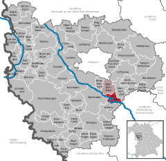
Coordinates 49°10′40″N 10°39′20″E / 49.17778°N 10.65556°ECoordinates: 49°10′40″N 10°39′20″E / 49.17778°N 10.65556°E Administration Country Germany State Bavaria Admin. region Middle Franconia District Ansbach Municipal assoc. Triesdorf Town subdivisions 6 Ortsteile Mayor Heinz Baum (CSU/Wählergruppe Eintracht) Basic statistics Area 15.16 km2 (5.85 sq mi) Elevation 419 m (1375 ft) Population 1,608 (31 December 2010)[1] - Density 106 /km2 (275 /sq mi) Other information Time zone CET/CEST (UTC+1/+2) Licence plate AN Postal code 91737 Area code 09826 Website www.ornbau.de Ornbau is a walled city in the district of Ansbach, in Bavaria, Germany. It is situated on the river Altmühl, 15 km southeast of Ansbach.
Contents
Smallest City (Stadt) in Bavaria
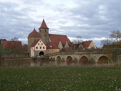
Ornbau is the smallest (population) city in the German state of Bavaria. Its designation as a city dates back to medieval times because a wall and a mote surround the city.
Medieval town
The wall and the cathedral church are approximately 1000 years old. The wall, the bridge, and the original steeple are still standing and in good condition. The town lies near the Roman town of Gunzenhausen. Gunzenhausen was an outpost on the Roman Limes Line, one of the largest structures ever constructed by mankind.
On the chimney of the "old schoolhouse" there are giant crane nests that have stood for centuries. They are a source of pride for the citizens of Ornbau.
German Mercedes-Benz Club rally
Every year, an estimated 500 classic Mercedes-Benz cars from throughout Germany, and Europe gather in Ornbau in the largest mercedesbenzclubs.de gathering of the year. Thousands attend annually, and a fireworks display to rival that of many small us cities is shown.
Adelshofen · Arberg · Aurach · Bechhofen · Bruckberg · Buch am Wald · Burgoberbach · Burk · Colmberg · Dentlein · Diebach · Dietenhofen · Dinkelsbühl · Dombühl · Dürrwangen · Ehingen · Feuchtwangen · Flachslanden · Gebsattel · Gerolfingen · Geslau · Heilsbronn · Herrieden · Insingen · Langfurth · Lehrberg · Leutershausen · Lichtenau · Merkendorf · Mitteleschenbach · Mönchsroth · Neuendettelsau · Neusitz · Oberdachstetten · Ohrenbach · Ornbau · Petersaurach · Röckingen · Rothenburg ob der Tauber · Rügland · Sachsen · Schillingsfürst · Schnelldorf · Schopfloch · Steinsfeld · Unterschwaningen · Wassertrüdingen · Weidenbach · Weihenzell · Weiltingen · Wettringen · Wieseth · Wilburgstetten · Windelsbach · Windsbach · Wittelshofen · Wolframs-Eschenbach · Wörnitz
References
- ^ "Fortschreibung des Bevölkerungsstandes" (in German). Bayerisches Landesamt für Statistik und Datenverarbeitung. 31 December 2010. https://www.statistikdaten.bayern.de/genesis/online?language=de&sequenz=tabelleErgebnis&selectionname=12411-009r&sachmerkmal=QUASTI&sachschluessel=SQUART04&startjahr=2010&endjahr=2010.
Categories:- Towns in Bavaria
- Ansbach district
- Middle Franconia geography stubs
Wikimedia Foundation. 2010.


