- Nittenau
-
Nittenau 

 NittenauLocation of the town of Nittenau within Schwandorf district
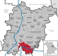
Coordinates 49°12′N 12°16′E / 49.2°N 12.26667°ECoordinates: 49°12′N 12°16′E / 49.2°N 12.26667°E Administration Country Germany State Bavaria Admin. region Oberpfalz District Schwandorf Mayor Karl Bley (SPD) Basic statistics Area 93.15 km2 (35.97 sq mi) Elevation 350 m (1148 ft) Population 8,369 (31 December 2010)[1] - Density 90 /km2 (233 /sq mi) Other information Time zone CET/CEST (UTC+1/+2) Licence plate SAD Postal code 93149 Area codes 09436, 09463, 09464 Website www.nittenau.de Nittenau is a municipality in the district of Schwandorf, in Bavaria, Germany. It is situated on the river Regen, 18 km southeast of Schwandorf, and 24 km northeast of Regensburg.
Altendorf · Bodenwöhr · Bruck in der Oberpfalz · Burglengenfeld · Dieterskirchen · Fensterbach · Gleiritsch · Guteneck · Maxhütte-Haidhof · Nabburg · Neukirchen-Balbini · Neunburg vorm Wald · Niedermurach · Nittenau · Oberviechtach · Pfreimd · Schmidgaden · Schönsee · Schwandorf · Schwarzach bei Nabburg · Schwarzenfeld · Schwarzhofen · Stadlern · Steinberg am See · Stulln · Teublitz · Teunz · Thanstein · Trausnitz · Wackersdorf · Weiding · Wernberg-Köblitz · Winklarn
References
- ^ "Fortschreibung des Bevölkerungsstandes" (in German). Bayerisches Landesamt für Statistik und Datenverarbeitung. 31 December 2010. https://www.statistikdaten.bayern.de/genesis/online?language=de&sequenz=tabelleErgebnis&selectionname=12411-009r&sachmerkmal=QUASTI&sachschluessel=SQUART04&startjahr=2010&endjahr=2010.
Categories:- Towns in Bavaria
- Schwandorf district
- Upper Palatinate geography stubs


Wikimedia Foundation. 2010.