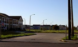
- Desire Projects
-
Desire Projects Abundance Square New Orleans Neighborhood Country United States State Louisiana City New Orleans Planning District District 7, Bywater District Elevation 0 ft (0 m) Coordinates 29°59′21″N 90°01′55″W / 29.98917°N 90.03194°W Area 0.22 sq mi (0.6 km2) - land 0.22 sq mi (1 km2) - water 0.00 sq mi (0 km2), 0% Population 660 (2000) Density 3,000 / sq mi (1,158 / km2) Timezone CST (UTC-6) - summer (DST) CDT (UTC-5) Area code 504 Desire Projects is a neighborhood and a former housing project of the city of New Orleans. A subdistrict of the Bywater District Area, its boundaries as defined by the City Planning Commission are: Higgins Boulevard to the north, Alvar Street to the east, Florida Boulevard to the south and Desire Street, Oliver White Avenue, Pleasure Street and Piety Street to the west.
Historically one of the city's most crime-ridden areas, mass demolition and other efforts drastically reduced the crime occurring in the neighborhood. It was located across Florida avenue from the Florida Projects. For its deplorable condition, it was known among locals as "Dirty D."
Contents
Geography
Desire Projects is located at 29°59′21″N 90°01′55″W / 29.98917°N 90.03194°W [1] and has an elevation of 0 feet (0.0 m)[2]. According to the United States Census Bureau, the district has a total area of 0.22 square miles (0.6 km2). 0.22 square miles (0.6 km2) of which is land and 0.00 square miles (0.0 km2) (0.00%) of which is water.
Adjacent Neighborhoods
- Desire Area (north, east & west)
- Florida Projects (south)
Boundaries
The City Planning Commission defines the boundaries of Desire Projects as these streets: Higgins Boulevard, Alvar Street, Florida Boulevard, Desire Street, Oliver White Avenue, Pleasure Street and Piety Street.[3]
Demographics
As of the census[4] of 2000, there were 660 people, 189 households, and 162 families residing in the neighborhood. The population density was 3,000 /mi² (1,100 /km²).
History
The Desire, which once had over 262 buildings, was completely torn down by 2003. Two of the original buildings were preserved for historical purposes. The area was in the midst of re-development and new construction when Hurricane Katrina inundated the historically low lying area.
When it was built in 1949, several other buildings were cleared to make room, including the Hideaway Club, where Fats Domino played regular gigs.
The U.S. Department of Housing and Urban Development Secretary announced that by July 2007, 100 of the eventual 500 houses would be built, as part of a development dubbed the "New Desire" or "Abundance Square." [1]
See also
References
- ^ "US Gazetteer files: 2010, 2000, and 1990". United States Census Bureau. 2011-02-12. http://www.census.gov/geo/www/gazetteer/gazette.html. Retrieved 2011-04-23.
- ^ "US Board on Geographic Names". United States Geological Survey. 2007-10-25. http://geonames.usgs.gov. Retrieved 2008-01-31.
- ^ Greater New Orleans Community Data Center. "Desire Development Neighborhood". http://gnocdc.org/orleans/7/16/index.html. Retrieved 2008-06-21.
- ^ "American FactFinder". United States Census Bureau. http://factfinder.census.gov. Retrieved 2008-01-31.
External links
Public Housing in New Orleans B.W. Cooper (Calliope) | Desire (Abundance) | Fischer | Florida | Guste (Melpomene) | Iberville | Lafitte | C.J. Peete (Magnolia) | St. Bernard | St. Thomas (River Garden)

Housing Authority of New Orleans Neighborhoods of the Bywater District of New Orleans, Louisiana Bywater | Desire Area | Desire Projects | Florida Area | Florida Projects | Marigny | St. Claude | St. Roch
Categories:- Neighborhoods in New Orleans, Louisiana
- Public housing in New Orleans, Louisiana
- Populated places in Louisiana with African American majority populations
- New Orleans, Louisiana stubs
Wikimedia Foundation. 2010.

