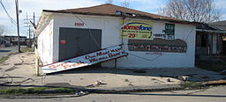
- Desire Area, New Orleans
-
Desire Area New Orleans Neighborhood Neighborhood grocery after Hurricane KatrinaCountry United States State Louisiana City New Orleans Planning District District 7, Bywater District Elevation 0 ft (0 m) Coordinates 29°59′39″N 90°02′04″W / 29.99417°N 90.03444°W Area 1.83 sq mi (4.7 km2) - land 1.72 sq mi (4 km2) - water 0.11 sq mi (0 km2), 6.01% Population 582 (2010) Density 318 / sq mi (123 / km2) Timezone CST (UTC-6) - summer (DST) CDT (UTC-5) Area code 504 Desire Area is a neighborhood of the city of New Orleans. A subdistrict of the Bywater District Area, its boundaries as defined by the City Planning Commission are: Gentilly Boulevard to the north, the Industrial Canal to the east, Florida Boulevard, Alvar Street, Higgins Boulevard, Piety Street, Pleasure Street, Oliver White Avenue, and Desire Street to the south and People's Avenue to the west.
Contents
Geography
Desire Area is located at 29°59′39″N 90°02′04″W / 29.99417°N 90.03444°W [1] and has an elevation of 0 feet (0.0 m)[2]. According to the United States Census Bureau, the district has a total area of 1.83 square miles (4.7 km2). 1.72 square miles (4.5 km2) of which is land and 0.11 square miles (0.3 km2) (6.01%) of which is water.
Adjacent Neighborhoods
- Gentilly Woods (north)
- Viavant/Venetian Isles (east)
- Bywater (south)
- Florida Projects (south)
- Desire Projects (south)
- Florida Area (south)
- Gentilly Terrace (west)
Boundaries
The City Planning Commission defines the boundaries of Desire Area as these streets: Gentilly Boulevard, the Industrial Canal, Florida Boulevard, Alvar Street, Higgins Boulevard, Piety Street, Pleasure Street, Oliver White Avenue, Desire Street, and People's Avenue.[3]
Demographics
As of the census[4] of 2000, there were 3,791 people, 1,328 households, and 963 families residing in the neighborhood. The population density was 2,204 /mi² (842 /km²).
See also
References
- ^ "US Gazetteer files: 2010, 2000, and 1990". United States Census Bureau. 2011-02-12. http://www.census.gov/geo/www/gazetteer/gazette.html. Retrieved 2011-04-23.
- ^ "US Board on Geographic Names". United States Geological Survey. 2007-10-25. http://geonames.usgs.gov. Retrieved 2008-01-31.
- ^ Greater New Orleans Community Data Center. "Desire Area Neighborhood". http://gnocdc.org/orleans/7/15/index.html. Retrieved 2008-06-21.
- ^ "American FactFinder". United States Census Bureau. http://factfinder.census.gov. Retrieved 2008-01-31.
Neighborhoods of the Bywater District of New Orleans, Louisiana Bywater | Desire Area | Desire Projects | Florida Area | Florida Projects | Marigny | St. Claude | St. Roch
Categories:- Neighborhoods in New Orleans, Louisiana
- New Orleans, Louisiana stubs
Wikimedia Foundation. 2010.

