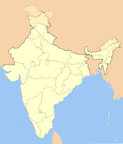
North Kawnpui

North Kawnpui
North Kawnpui
—  city  —
North Kawnpui
Location of North Kawnpui
in Mizoram
Coordinates 24°03′05″N 92°40′20″E / 24.0513400°N 92.6721900°E / 24.0513400; 92.6721900Coordinates: 24°03′05″N 92°40′20″E / 24.0513400°N 92.6721900°E / 24.0513400; 92.6721900
Country India
State Mizoram
District(s) Kolasib
Population 6,328 (2001)
Time zone IST (UTC+05:30)

North Kawnpui is a census town in Kolasib district in the Indian state of Mizoram.

Demographics

As of 2001 India census[1], North Kawnpui had a population of 6328. Males constitute 50% of the population and females 50%. North Kawnpui has an average literacy rate of 83%, higher than the national average of 59.5%: male literacy is 84%, and female literacy is 82%. In North Kawnpui, 15% of the population is under 6 years of age.

References


Wikimedia Foundation. 2010.

Игры ⚽ Поможем решить контрольную работу

Look at other dictionaries:

  • List of India-related articles — Articles (arranged alphabetically) related to India or Indian culture include: NOTOC List of India related topics People are listed by their first names. 1231 SGM 3 STR 2002 Gujarat violence 2005 in India ( previous years ) 2004 Indian Ocean… …   Wikipedia

  • Index of India-related articles — Articles (arranged alphabetically) related to India or Indian culture include: List of India related topics Contents: Top · 0–9 A B C D E F G H I J K L M N O P Q R S T U V W X Y Z People are listed by their first names …   Wikipedia

  • Churachandpur district — This article is about the district. For its eponymous headquarters, see Churachandpur. Churachandpur   district   …   Wikipedia

  • Chakma Autonomous District Council — The Chakma Autonomous District Council was formed under the Sixth schedule of the Constitution of India on April 29, 1972. The Council is the replication of the state assembly and exercises executive power over specially allotted departments. The …   Wikipedia

  • Serchhip — Infobox Indian Jurisdiction native name = Serchhip | type = town | latd = 23.3 | longd = 92.83 locator position = left | state name = Mizoram district = Serchhip leader title = leader name = altitude = 888 population as of = 2002 population total …   Wikipedia

  • Kolasib district — This article is about the district. For its eponymous headquarters, see Kolasib. Kolasib district Location of Kolasib district in Mizoram State …   Wikipedia

Share the article and excerpts

Direct link
Do a right-click on the link above
and select “Copy Link”