- Culbertson's Path
-
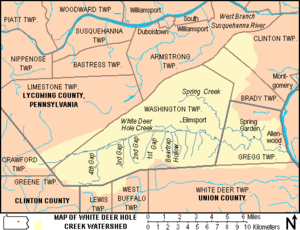
Culbertson's Path was a Native American trail in north central Pennsylvania in the United States, which connected the Great Island Path with the Sheshequin Path. The eastern / southern end of the path was on the West Branch Susquehanna River at what is now the unincorporated village of Allenwood in Gregg Township in Union County. The northern / western end was in Old Lycoming Township just north of what is now the city of Williamsport in Lycoming County.
Culbertson's Path followed White Deer Hole Creek west from Allenwood, then left to follow Spring Creek north, crossing North White Deer Ridge and Bald Eagle Mountain and following Mosquito Run to the West Branch Susquehanna River at the modern borough of Duboistown. Here it forded the river at Culbertson's Ripples (approximately the modern location of the Arch Street Bridge). From Allenwood to Spring Creek, Culbertson's Path and the Great Island Path shared the same trail. The Great Island Path led west to the Great Island (modern Lock Haven) and paths there led west to the Allegheny River and beyond.
After fording the river, Culbertson's Path crossed the Great Shamokin Path (which also led west to the Great Island and beyond) to the village named "French Margaret's Town" on the west bank of Lycoming Creek (modern Williamsport). Culbertson's Path then continued north to modern Old Lycoming Township, where it joined the major Sheshequin Path, which lead north up Lycoming Creek towards the North Branch of the Susquehanna River, modern New York, and the Iroquois there.
South of Allenwood, there were connections via the Great Island Path to the village of Shamokin (modern Sunbury), as well as the Virginia Road and the Penns Creek and Mahanoy Paths.[1]
The path was only wide enough for one person, but the early inhabitants of White Deer Hole valley broadened the trail to DuBoistown to take grain to Culbertson's mill on Mosquito Run (leading them to call it "Culbertson's path").[2] In 2006, there is still a "Culbertson's Trail", for hiking over North White Deer Ridge and Bald Eagle Mountain from Pennsylvania Route 554 to Duboistown.[3]
References
- ^ Wallace, Paul A.W. (1987). Indian Paths of Pennsylvania (Fourth Printing ed.). Harrisburg, Pennsylvania: Pennsylvania Historical and Museum Commission. p. 42. ISBN 0-89271-090-X. "(Note: ISBN refers to 1998 impression.)"
- ^ Meginness, John Franklin (1892). "Chapter XXXIX. Washington, Clinton, Armstrong, and Brady [Townships."]. History of Lycoming County, Pennsylvania: including its aboriginal history; the colonial and revolutionary periods; early settlement and subsequent growth; organization and civil administration; the legal and medical professions; internal improvement; past and present history of Williamsport; manufacturing and lumber interests; religious, educational, and social development; geology and agriculture; military record; sketches of boroughs, townships, and villages; portraits and biographies of pioneers and representative citizens, etc. etc. (1st Edition ed.). Chicago, IL: Brown, Runk & Co.. ISBN 0-7884-0428-8. http://www.usgennet.org/usa/pa/county/lycoming/history/Chapter-39.html. Retrieved 2006-03-21. "(Note: ISBN refers to Heritage Books July 1996 reprint. URL is to a scan of the 1892 version with some OCR typos)."
- ^ Pennsylvania Department of Conservation and Natural Resources. "Tiadaghton State Forest Map" (PDF). http://www.dcnr.state.pa.us/forestry/stateforests/maps/fd12_map.pdf. Retrieved 2006-11-18.
Categories:- Native American trails in the United States
- Historic trails and roads in Pennsylvania
- Transportation in Union County, Pennsylvania
- Transportation in Lycoming County, Pennsylvania
Wikimedia Foundation. 2010.

