- Toussaint Louverture International Airport
-
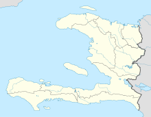
Toussaint Louverture International Airport IATA: PAP – ICAO: MTPP Summary Airport type Public Owner Office National de l´Aviation Civile Operator Autorité Aeroportuaire Nationale Serves Port-au-Prince Location Port-au-Prince Elevation AMSL 109 ft / 33 m Coordinates 18°34′48″N 072°17′33″W / 18.58°N 72.2925°WCoordinates: 18°34′48″N 072°17′33″W / 18.58°N 72.2925°W Map Location in Haiti Runways Direction Length Surface m ft 10/28 3,040 9,974 Asphalt Source: DAFIF[1]
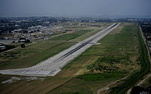
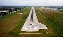
Toussaint Louverture International Airport (French: Aeroport International Toussaint Louverture) (IATA: PAP, ICAO: MTPP) is an international airport located in Tabarre, near Port-au-Prince in Haiti. The airport is currently the busiest in Haiti.Contents
History
In the 1940s a military and civil airfield, Bowen Field, was established near Baie de Port-au-Prince providing passenger air service by Compagnie Haitienne de Transports Aériens.[citation needed] It served as an airbase for the U.S. military in Haiti in the 1950s and 1960s.
Developed with grant money from the United States Government, the current airport opened in 1965 as Francois Duvalier International Airport, named after then Haitian president Francois "Papa Doc" Duvalier. Following the resignation of Duvalier's son and successor Jean Claude Duvalier in 1986, the airport was renamed Port-au-Prince International Airport, before being renamed again as Toussaint Louverture International Airport in 2003, in honour of the Haitian revolutionary leader.
Facilities
The main building of the airport works as the International Terminal. It consists of a two storey concrete and glass structure. Lounges and a few retail stores are located on the second floor of the main building. Check-in counters, gates and immigration facilities are on the lower floor. The Guy Malary Terminal (named after former Haitian Justice Minister Guy Malary) is used for domestic flights. There are further buildings used for general aviation and cargo flights. The airport has 3 jet bridges, but most passengers walk onto aircraft from mobile stairs. The ramp area can handle 12 planes.[2]
Currently, international passengers are transported by bus to a warehouse near the terminal where they go through customs and immigration processing. The jetways are still operational. American Airlines still operates check-in, security, and boarding on the west end of the terminal near Gate 1. [3]
Access
The airport can be accessed by car (with parking space being located adjacent to the terminal building) or by National Bus Route 1.
Airlines and destinations
Airlines Destinations Aero Caribbean Santiago de Cuba[4] Air Canada Montréal-Trudeau Air Caraïbes Cayenne, Fort-de-France, Paris-Orly, Pointe-à-Pitre, Santo Domingo, St Maarten Air France Miami, Pointe-à-Pitre Air Transat Montréal-Trudeau Air Turks and Caicos Providenciales Aerolíneas Mas Santiago de los Caballeros,[5] Santo Domingo-La Isabela American Airlines Fort Lauderdale, Miami, New York-JFK Continental Airlines Newark Copa Airlines Panama City Delta Air Lines New York-JFK Insel Air Curaçao, Miami, St Maarten SALSA d'Haiti Cap-Haiten Spirit Airlines Fort Lauderdale Sunwing Airlines Montreal-Trudeau Tortug' Air Jacmel, Jérémie, Les Cayes, Port-de-Paix Cargo airlines
Airlines Destinations ABX Air Miami Amerijet International Miami, Santiago, Santo Domingo IBC Airways Miami Hub Operations
As of July 2011, Toussaint Louverture serves as operating hub for scheduled domestic airlines SALSA d'Haiti and Tortug' Air. Additionally, the charter airline Sunrise Airways is based out of the Port-au-Prince airport.
Incidents and accidents
- March 7, 1980: A Learjet (N211MB) operating on a corporate charter flight on behalf of 'Merchant Bank' crashed in the hills on arrival at airport. One passenger and two crew members died.[6]
- 12 July 1980: A Douglas C-47 crashed on approach, killing all three people on board. The aircraft was being used illegally to transport marijuana.[7]
- December 7, 1995: An Air St. Martin Beechcraft 1900D aircraft (F-OHRK) hit a mountain at an altitude of 5,030 feet (1,533 m), 30 kilometres (19 mi) away from airport. Two crew members and 18 passengers (which were illegal immigrants to Guadeloupe) were killed.[8]
- February 12, 1996: A Haiti Express GAF Nomad aircraft (N224E) crashed shortly after taking off. Two crew members and 8 passengers died.[9]
- August 31, 2007: A Caribintair Cessna Grand Caravan (HH-CAR) crashed shortly after takeoff 5 kilometres (3 mi) away from the airport. There were no fatal injuries.[10]
- September 11, 2007: Only eleven days after the previous accident another plane crash of a Caribintair Cessna Grand Caravan (HH-CAW) occurred near the airport, this time upon landing 10 kilometres (6 mi) short of the runway.[11]
See also
- Jacmel Airport, another airport used for 2010 earthquake relief flights in Haiti
- Operation Unified Response, US military relief effort for the January 2010 earthquake in Haiti
- List of airports in Haiti
References
- ^ Airport information for MTPP at World Aero Data. Data current as of October 2006.Source: DAFIF.
- ^ Globe and Mail, "A once sleepy airport is now Haiti's overstretched lifeline", Paul Koring, 19 January 2010 (accessed 20 January 2010)
- ^ Bahret, Brian (2010-01-22). "Russian plane helps U.S. move mobile air traffic control tower to Haiti". Air Force Print News Today. Air Force News Service. http://www.homestead.afrc.af.mil/news/story_print.asp?id=123186874. Retrieved 31 July 2011.
- ^ Aero Caribbean flight schedules
- ^ http://www.aerolineasmas.com/BodyText.aspx?Pagina=250
- ^ 1980 accident report at the aviation safety network.
- ^ "Accident description". Aviation Safety Network. http://aviation-safety.net/database/record.php?id=19800712-1. Retrieved 3 July 2010.
- ^ 1995 accident report at the aviation safety network.
- ^ 1996 accident report at the aviation safety network.
- ^ August 2007 accident report at the aviation safety network.
- ^ September 2007 accident report at the aviation safety network.
External links
2010 Haiti earthquake Humanitarian response · Relief efforts · Casualties · Damaged infrastructure · Cholera outbreak Affected geography Enriquillo-Plantain Garden fault zone – Haiti – Ouest: Port-au-Prince Arrondissement (Port-au-Prince [ Bel Air ] · Carrefour · Cité Soleil · Gressier · Pétionville) · Léogâne Arrondissement (Léogâne · Grand-Goâve · Petit-Goâve) — Sud-Est: Jacmel Arrondissement (Jacmel)Humanitarian response National governments · NGOs · For-profit organizations · MINUSTAHAid operations Unified Response (USA) · Hestia (Canada) · Séisme Haiti (France) · White Crane (Italy) · Danbi (Republic of Korea) · Hispaniola (Spain) · United Nations Security Council Resolution 1908 (MINUSTAH)Benefits & fundraising Canada for Haiti · Ensemble pour Haïti · Hope for Haiti Now (album) · Hit for Haiti · Clinton Bush Haiti Fund · Digicel Haiti Earthquake Relief Fund · "Everybody Hurts" · "We Are the World 25 for Haiti" · "Somos El Mundo 25 Por Haiti" · Young Artists for Haiti ("Wavin' Flag") · "I Put a Spell on You" · "We Are the World 25 for Haiti (YouTube Edition)" · Download to Donate for HaitiSee also: List of earthquakes in Haiti and List of 21st-century earthquakesCategories:- Airports in Haiti
- Buildings and structures in Port-au-Prince
- 2010 Haiti earthquake relief
Wikimedia Foundation. 2010.


