- Orte
-
Orte — Comune — Comune di Orte 
Coat of armsLocation of Orte in Italy
 Orte
OrteCoordinates: 42°27′37″N 12°23′11″E / 42.46028°N 12.38639°ECoordinates: 42°27′37″N 12°23′11″E / 42.46028°N 12.38639°E Country Italy Region Lazio Province Viterbo (VT) Frazioni Orte Scalo Government - Mayor Dino Primieri Area - Total 70.16 km2 (27.1 sq mi) Elevation 132 m (433 ft) Population (31 December 2006) - Total 8,364 - Density 119.2/km2 (308.8/sq mi) Demonym Ortani Time zone CET (UTC+1) - Summer (DST) CEST (UTC+2) Postal code 01028 Dialing code 0761 Patron saint St. Giles Abbot Saint day September 1 Website Official website Orte is a comune (municipality) in the province of Viterbo, in the Italian region Latium Lazio, located about 60 km north of Rome and about 24 km east of Viterbo. As of 31 December 2006, Orte had a population of 8,364.
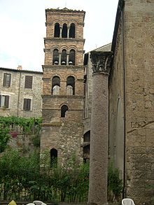 The Romanesque bell tower of the church of San Silvestro, Orte.
Orte is situated in the Tiber valley on a high tuff cliff, encircled to North and East from a handle of the Tevere river. It is an important road and rail hub.
Contents
History
The Etruscans inhabited the area from the 6th century BC and called it *Hurta,[1] as testified by the findings in a necropolis nearby, now preserved in the Vatican Museums. Orte was theatre of battles between Etruscans and Romans (310 and 283 BC), near the Vadimone lake, in both of which the Romans were victorious.
The Romans domination made it the municipality of Horta (also Hortanum).[2] Under the rule of Augustus it received numerous public works. Subsequently, because of its strategic position, Orte was occupied by the Ostrogoths, the Byzantines and the Lombards.
In the Middle Ages the city was never seat of a fief, becoming a free comune under a podestà.
Events
- Saint'Egidio Abate's Day and Ottava of Saint'Egidio: from 31 August to the second Sunday in September. A Medieval festival with shows, fairs, conventions, seminaries of study, art exhibitions of art and archery competitions (the "Palio", contented by the archers of the Seven Contrade).
- Religious procession of Dead Christ: every Friday before Easter. A torchlight procession representing early religions orders ("Confraternite").
Transport
Orte railway station, opened in 1865, forms part of the Florence–Rome railway and the Rome–Ancona railway. It is situated in Piazza Giovanni XXIII, in the locality of Orte Scalo, approximately two kilometres southeast of the town centre.
External links
References
- ^ Chiesa, Tarquinia: archeologia e prosopografia tra ellenismo e romanizzazione, 2006, p.267.
- ^ John Murray, A dictionary of Greek and Roman geography, Volume 1, 1873, p.1091
Lazio · Comuni of the Province of Viterbo Acquapendente · Arlena di Castro · Bagnoregio · Barbarano Romano · Bassano Romano · Bassano in Teverina · Blera · Bolsena · Bomarzo · Calcata · Canepina · Canino · Capodimonte · Capranica · Caprarola · Carbognano · Castel Sant'Elia · Castiglione in Teverina · Celleno · Cellere · Civita Castellana · Civitella d'Agliano · Corchiano · Fabrica di Roma · Faleria · Farnese · Gallese · Gradoli · Graffignano · Grotte di Castro · Ischia di Castro · Latera · Lubriano · Marta · Montalto di Castro · Monte Romano · Montefiascone · Monterosi · Nepi · Onano · Oriolo Romano · Orte · Piansano · Proceno · Ronciglione · San Lorenzo Nuovo · Soriano nel Cimino · Sutri · Tarquinia · Tessennano · Tuscania · Valentano · Vallerano · Vasanello · Vejano · Vetralla · Vignanello · Villa San Giovanni in Tuscia · Viterbo · Vitorchiano
Categories:- Cities and towns in Lazio
- Communes of the Province of Viterbo


Wikimedia Foundation. 2010.