- Dartmouth Commons
-
Dartmouth Common 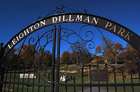
Entrance to Leighton Dillman Park, Dartmouth CommonsType Public park Location Halifax, Nova Scotia Area 300 acres (120 ha) Created 1700s Operated by City of Halifax The Dartmouth Common is an approximately 300 acres (1.2 km2) area of land set aside by the government in the late 18th century for the settlers common use in Dartmouth Nova Scotia, Canada. Much of it is maintained by the Halifax Regional Municipality, Today the most prominent area is called the Leighton Dillman Scenic Garden, which is named after a voluntary keeper of the garden.
Other areas of the common are used by: baseball fields, the former Dartmouth City Hall, then the Dartmouth Regional Library then after that the Dartmouth Heritage Museum, the Dartmouth Sportsplex, Dartmouth High School, Bicentennial Jr. High School, an elementary school called "Park School" (since torn down) and two burial grounds. Between the Dartmouth Sportsplex and Dartmouth High School there is an urban forest, a green space in the downtown corridor. The former Dartmouth Heritage Museum building has since been demolished, and the area it stands on was turned back into park land.
Under the "Halifax Regional Municipality Act" the municipality cannot develop the Dartmouth Common, nor charge a fee to use the ball fields. The Dartmouth common section of "Halifax Regional Municipality Act" reads:
529 (1) In this Section, "Dartmouth common" means the common of Dartmouth so far as it was vested in the City of Dartmouth on April 22, 1986. (2) The Halifax Regional Municipality shall not sell, lease, license or otherwise alienate the Dartmouth common. (3) Subject to subsection (4), no person shall build on the Dartmouth common. (4) A person may build an addition to a building located on the lands described in the Schedule to Chapter 87 of the Acts of 1994, An Act to Amend Chapter 68 of the Acts of 1986, the Dartmouth Common Act, if the building and the addition are both totally located on those lands. (5) The Dartmouth common is held by the Halifax Regional Municipality in trust for the inhabitants of the municipality. 1998, c. 18, s. 529.
Recent amendments to the Act:
It is recommended that subsection 529 (4) be renumbered to 529 (4)(a) and clause 529(4)(b) be added as follows: (b) The Municipality may build, expand or improve: i) transit facilities, fronting on Nantucket Avenue; and ii) parking lots for the Sportsplex, on the Dartmouth Common to a maximum of 6 acres (24,000 m2).
External links
Coordinates: 44°40′8.72″N 63°34′17.72″W / 44.6690889°N 63.5715889°W
Categories:- Parks in the Halifax Regional Municipality
- Halifax County, Nova Scotia geography stubs

Wikimedia Foundation. 2010.