Chocorua River

Chocorua River

Coordinates: 43°48′52″N 71°11′52″W / 43.8144°N 71.1978°W / 43.8144; -71.1978

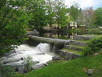
A small dam on the Chocorua River in the village of Chocorua

The Chocorua River is a 15.2-mile (24.5 km)[1] river located in eastern New Hampshire in the United States. It is a tributary of the Bearcamp River, part of the Ossipee Lake / Saco River watershed leading to the Atlantic Ocean.

The Chocorua River rises on the eastern slopes of Mount Chocorua, a prominent rocky knob at the southeast margin of the White Mountains. The river flows south into lowlands at the base of the mountain and arrives at Chocorua Lake, noted for its outstanding view of Mount Chocorua. Beyond the lake, the river flows south to the village of Chocorua with a picturesque mill dam, then continues into the flat, sandy Ossipee Lake region, reaching the Bearcamp River at West Ossipee.

New Hampshire Route 16 parallels the Chocorua River for most of its length.

Local history

In the early 20th century, innkeepers purchased the granite mill dam at the southern end of Moore's Pond on the river in Chocorua village. In 1912, the owners of the Chocorua Inn converted the mill dam into a hydroelectric operation hoping to supply energy to part of the town. A year or so later the dam was demolished in a flood, never to be reconstructed. As the eastern portion of the dam was breached, the levee broke and released two thirds of the pond in a few hours, causing the water level to drop 15 feet (4.6 m) and allowing former marshlands to thrive again.

References


Wikimedia Foundation. 2010.

Игры ⚽ Поможем написать реферат

Look at other dictionaries:

  • Chocorua Lake — The lake with the summit of Mount Chocorua casting a reflection Location Carroll County, New Hampshire Coordinates …   Wikipedia

  • Chocorua — may refer to a place name in the White Mountains of New Hampshire, United States: Mount Chocorua, a distinctive rocky summit Chocorua, New Hampshire, a village in the town of Tamworth near the mountain Chocorua Lake, at the base of the mountain… …   Wikipedia

  • Mount Chocorua — from Fowler s Mill Road Elevation 3,478 ft (1,060 m)  …   Wikipedia

  • Swift River (Bearcamp River) — The Swift River is an 8.3 mile long (13.4 km) [ [http://www.granit.sr.unh.edu New Hampshire GRANIT state geographic information system] ] river located in eastern New Hampshire in the United States. It is a tributary of the Bearcamp River, part… …   Wikipedia

  • Albany, New Hampshire — Infobox Settlement official name = Albany, New Hampshire nickname = motto = image imagesize = image caption = mapsize = 250px map caption = Location in Carroll County, New Hampshire settlement type = Town mapsize1 = map caption1 = subdivision… …   Wikipedia

  • List of rivers of New Hampshire — This is a list of rivers and significant streams in the U.S. state of New Hampshire.All watercourses named River (freshwater or tidal) are listed here, as well as other streams which are either subject to the… …   Wikipedia

  • Liste der Flüsse in New Hampshire — Aufgezählt sind alle Wasserläufe im US Bundesstaat New Hampshire, die länger als 16 km (10 Meilen) sind oder staatlichen Uferschutz haben. Flüsse können dann Uferschutz haben, wenn sie die Flussordnungszahl 4 haben oder größer sind.… …   Deutsch Wikipedia

  • List of New Hampshire covered bridges — This is a list of New Hampshire covered bridges. There are fifty four historic wooden covered bridges currently standing in the U.S. state of New Hampshire.Alphabetically by bridge name (locations in parentheses):*Albany (Albany) (two newer… …   Wikipedia

  • National Register of Historic Places listings in Carroll County, New Hampshire — Location of Carroll County in New Hampshire This is a list of the National Register of Historic Places listings in Carroll County, New Hampshire. This is intended to be a complete list of the properties and districts on the National Register of… …   Wikipedia

  • Sandwich Range — Geobox|Range name = Sandwich Range native name = other name = other name1 = image size = image caption = The Sandwich Range as seen looking west from Mount Chocorua. Summits include Mount Paugus (mid foreground), Mount Whiteface (horizon mid… …   Wikipedia

Share the article and excerpts

Direct link
Do a right-click on the link above
and select “Copy Link”