- Klis
-
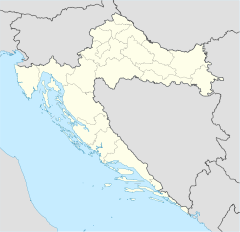
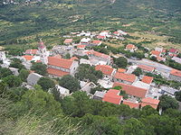
Klis (Croatian: Klis, Italian: Clissa, Turkish: Kilis) is a village located around a mountain fortress bearing the same name. It is located in central Dalmatia, Croatia, located just northeast of Solin and Split near the eponymous mountain pass.[1] It has a population of 2,621, totalling 4,421 together with the eight other villages in its municipality (census 2001).
The Klis mountain pass separates the mountains Mosor and Kozjak at the altitude of 360m. It has had a major strategic value throughout history, because any inland force passing through Klis would have been able to easily reach the entire region of Split and Kaštela. During the Ottoman wars in Europe, an already existing Roman fortress on a nearby hill was expanded into Klis Fortress. It was sanjak centre in Province of Bosnia during Ottoman rule. Klis was also ruled by Kingdom of Bosnia, Venetian Republic[2] and Austria-Hungary. Due to its geographical position, Klis is also susceptible to a rather strong bura wind.
See also
- Klis Fortress
- Petar Kružić
References
- ^ The Rough Guide to Croatia by Jonathan Bousfield
- ^ When Ethnicity did not Matter in the Balkans: by John Van Antwerp Fine.page 173.
External links
Subdivisions of Split-Dalmatia County Cities and towns Municipalities Baška Voda · Bol · Brela · Cista Provo · Dicmo · Dugi Rat · Dugopolje · Gradac · Hrvace · Jelsa · Klis · Lećevica · Lokvičići · Lovreć · Marina · Milna · Muć · Nerežišća · Okrug · Otok · Podbablje · Podgora · Podstrana · Postira · Prgomet · Primorski Dolac · Proložac · Pučišća · Runovići · Seget · Selca · Sućuraj · Sutivan · Šestanovac · Šolta · Tučepi · Zadvarje · Zagvozd · ZmijavciCoordinates: 43°34′N 16°31′E / 43.567°N 16.517°E
Categories:- Kingdom of Croatia
- Former capitals of Croatia
- Municipalities of Croatia
- Split-Dalmatia County
- Split-Dalmatia County geography stubs
Wikimedia Foundation. 2010.


