- Orepuki
-
 Orepuki
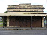
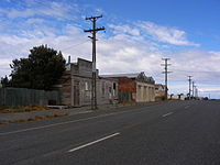
Orepuki in Southland, New Zealand is a small country township on the coast of Te Waewae Bay some 20 minutes from Riverton, 15 minutes from Tuatapere and 50 minutes from Invercargill that sits at the foot of the Longwood Range. Once a thriving gold mining settlement of 3000 people, today Orepuki is something of a ghost town with an assortment of abandoned stores, goldmining relics and sluicing scars as the only reminders of its former glory.
History
In pre-European times, local Māori used the unique and highly prized garnet gemstones on the beach to polish and sharpen their 'toki' or adzes/axes. European sealer John Boultbee noted in 1827 that there was an "old and small" Māori village situated near present day Orepuki [1]. It seems likely that any trace of this village was washed away by later goldminers and their sluicing activities. The English translation of 'Orepuki' has been subject to numerous theories: Aro-puke or 'crumbling cliffs' being one of the more popular suggestions.
The European origins of Orepuki township begin with the discovery of gold in the beaches black sand in 1865. The first tent town of Hirstfield sprung up near Monkey Island (in the lee of which ships anchored). Several years later a slightly more permanent second township was constructed to the north of the present day village, known as Garfield. Mining operations however, dictated that this site was on gold bearing land and the people and their houses, including the school, shifted to the present site to allow further mining. On 25 May 1885 a branch line railway was opened to Orepuki, providing it with swift transport to Invercargill. On 1 October 1903, a further extension beyond Orepuki was opened and the line ultimately became the Tuatapere Branch. The section of line between Riverton and Tuatapere closed on 30 July 1976. Orepuki station building still stands, relocated to serve other purposes on a farmer's paddock. Other industries to have operated in Orepuki include: sawmilling, coal mining, a shale works [2], a smelter to extract platinum, a flax mill and farming which remains as the main industry today. An array of old buildings still exist and currently the township supports a pub, a bowling green, a community hall, a church [3] and a population of around 100 people. Orepuki primary school closed in 2003.
The area is famous for a number of former All Blacks, world champion shearers, and its odd trees which appear to be in a perpetual gale, even in complete calm (frequent strong salt winds from the sea have warped and bent many trees by nearly 90°).
Surrounding areas include Pahia, Round Hill, Wakapatu, Ruahine, Colac Bay, Waihoaka, Te Waewae and Te Tua.
Nearby attractions
- Monkey Island; [4] a small island and mini lagoon off the southern end of the beach. Accessible during low tide, with a small walking track. Local Māori used the island as a traditional lookout for whales and named it 'Te Puka o Takitimu', or the 'Anchorstone of Takitimu' waka/canoe.
- Gemstone Beach; [5] situated ½ km north of Orepuki, this wild beach contains semi-precious gemstone such as: garnet, orbicular jasper, garnet sands, rodinguite quartz, semi nephrite, fossil worm casts, oil shale and elusive sapphire.
External links
- Riverton to Orepuki Goldfields
- Orepuki on the Western Southland Website
- A to Z guide. [7]
Towns and communities in the Southland District Territorial authority Athol · Balfour · Browns · Centre Bush · Clifden · Colac Bay · Curio Bay · Dacre · Dipton · Drummond · Edendale · Fairfax · Five Rivers · Fortrose · Garston · Gorge Road · Hedgehope · Limehills · Lochiel · Lumsden · Makarewa · Milford Sound · Manapouri · Mossburn · Nightcaps · Oban · Ohai · Otapiri · Orepuki · Otautau · Pahia · Riversdale · Riverton · Springhills · Te Anau · Thornbury · Tokanui · Tuatapere · Waianiwa · Waikaia · Waikawa · Waimahaka · Wallacetown · Winton · Woodlands · Wyndham
Categories:- Southland Region
- Southern Scenic Route
- Ghost towns in New Zealand


Wikimedia Foundation. 2010.