- Middle Palisade
-
Middle Palisade 
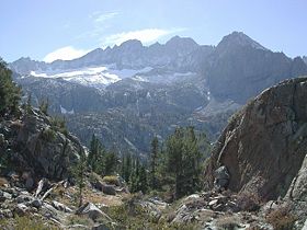
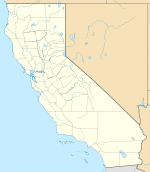
Middle Palisade, from Lone Pine Creek drainageElevation 14,018 ft (4,273 m) [1][2] Prominence 1,085 ft (331 m) [2] Parent peak North Palisade[3] Listing SPS Mountaineers peak[4] Location Location in California Location Fresno and Inyo counties, California, USA Range Sierra Nevada Coordinates 37°04′12″N 118°28′12″W / 37.07°N 118.47°WCoordinates: 37°04′12″N 118°28′12″W / 37.07°N 118.47°W[5] Topo map USGS Split Mountain Climbing First ascent August 26, 1921 by Francis Farquhar and Ansel Hall[6] Easiest route East Face: Scramble class 3[7] Middle Palisade is a peak in the Palisades group, part of the central Sierra Nevada mountain range in the US state of California. It is the twelfth highest peak in the state.
Several routes involving exposed scrambling and/or easy technical rock climbing (class 4) exist on the various flanks of Middle Palisade. Some routes involve travel on the Middle Palisade Glacier. The easiest route involves scrambling (class 3) up a chute in the east face of the peak.[7]
See also
 Media related to Palisades at Wikimedia Commons
- List of California fourteeners
- Mountain peaks of California
- Palisades of the Sierra Nevada
References
- ^ The NGVD 29 elevation of 14,012 feet was converted using VERTCON to the NAVD 88 elevation of 14,018 feet.
- ^ a b "Middle Palisade, California". Peakbagger.com. http://www.peakbagger.com/peak.aspx?pid=2732. Retrieved 2009-01-25.
- ^ "Whitney IV. P1000s, California Mountain Atlas". Peaklist.org. http://www.PeakList.org/CAmtnatlas/P1000/tables/Whitney4.html. Retrieved 2008-09-08.
- ^ "Sierra Peaks Section List". Angeles Chapter, Sierra Club. http://angeles.sierraclub.org/sps/spslist.pdf. Retrieved 2009-01-25.
- ^ "Middle Palisade". Geographic Names Information System, U.S. Geological Survey. http://geonames.usgs.gov/pls/gnispublic/f?p=gnispq:3:::NO::P3_FID:1654925. Retrieved 2009-01-25.
- ^ Farquhar, Francis P. (1926). Place Names of the High Sierra. San Francisco: Sierra Club. http://www.yosemite.ca.us/library/place_names_of_the_high_sierra/p.html. Retrieved 2009-01-25.
- ^ a b Roper, Steve (1976). The Climber's Guide to the High Sierra. Sierra Club Books. pp. 216–217. ISBN 0-87156-147-6.
External links
- "Middle Palisade". SummitPost.org. http://www.summitpost.org/page/150514. Retrieved 2011-05-26.
- USGS. Split Mountain quadrangle, California (Map). 1:24000, 7.5 Minute Topographic. http://www.topoquest.com/map-detail.php?usgs_cell_id=71684. Retrieved 2009-01-25.
Categories:- Fourteeners of California
- Mountains of Kings Canyon National Park
- Mountains of the John Muir Wilderness
- Mountains of Fresno County, California
- Mountains of Inyo County, California
- California geography stubs
Wikimedia Foundation. 2010.

