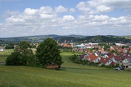
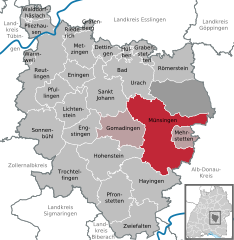
- Münsingen, Germany
-
Münsingen Münsingen 
Coordinates 48°24′46″N 9°29′43″E / 48.41278°N 9.49528°ECoordinates: 48°24′46″N 9°29′43″E / 48.41278°N 9.49528°E Administration Country Germany State Baden-Württemberg Admin. region Tübingen District Reutlingen Town subdivisions 14 Stadtteile Mayor Mike Münzing Basic statistics Area 116.05 km2 (44.81 sq mi) Elevation 707 m (2320 ft) Population 14,491 (31 December 2010)[1] - Density 125 /km2 (323 /sq mi) Other information Time zone CET/CEST (UTC+1/+2) Licence plate RT Postal code 72525 Area codes 07381, 07383, 07384 Website www.muensingen.de Münsingen is a town in the district of Reutlingen, Baden-Württemberg, Germany. It is situated 23 km southeast of Reutlingen, and 37 km west of Ulm.
Contents
History
The name Münsingen is assumed to be derrived of an alemannic chief called Munigis, who founded a settlement on the present-day city boundaries. In 775 Münsingen is mentioned for the first time on a deed of gift of Lorsch Abbey. The church of Münsingen is first mentioned in 804. After the rule of the Franks the village went to the county of Württemberg-Urach, which sold it in 1263 to Ulrich I . In 1339 Münsingen was granted Town privileges. Through the partition of Württemberg it came under the purview of Urach, until in 1482 the Treaty of Münsingen declared the re-unification of the County of Württemberg. On October 23, 1654 it became an administrative center of regional importance. From 1938 to 1973 Münsingen was capital of the district of Münsingen.
In 1895 the German Empire began the construction of a Proving ground. Later this became the Duke-Albrecht-Barracks. It was closed on March, 31, 2004. The ground was transformed into a settlement.
International relations
Münsingen, Germany is twinned with:
References
- ^ "Bevölkerung und Erwerbstätigkeit" (in German). Statistisches Landesamt Baden-Württemberg. 31 December 2009. http://www.statistik-bw.de/Veroeffentl/Statistische_Berichte/3126_10001.pdf.
External links
Bad Urach | Dettingen an der Erms | Engstingen | Eningen | Gomadingen | Grabenstetten | Grafenberg | Hayingen | Hohenstein | Hülben | Lichtenstein | Mehrstetten | Metzingen | Münsingen | Pfronstetten | Pfullingen | Pliezhausen | Reutlingen | Riederich | Römerstein | Sonnenbühl | St. Johann | Trochtelfingen | Walddorfhäslach | Wannweil | ZwiefaltenCategories:- Geography articles needing translation from German Wikipedia
- Towns in Baden-Württemberg
- Reutlingen district
- Tübingen region geography stubs
Wikimedia Foundation. 2010.


