Lost River (New Hampshire)
- Lost River (New Hampshire)
-
Coordinates: 44°01′12″N 71°44′04″W / 44.0201°N 71.7345°W / 44.0201; -71.7345
The Lost River (shown on USGS maps as Moosilauke Brook for part of its course) is a 6.5-mile-long (10.5 km)[1] stream located in the White Mountains of New Hampshire in the United States. It is a tributary of the Pemigewasset River, part of the Merrimack River watershed.
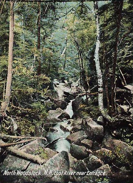
The Lost River begins in Kinsman Notch, one of the major passes through the White Mountains. As it flows through the notch, it passes through Lost River Gorge, an area where enormous boulders falling off the flanking walls of the notch at the close of the last Ice Age have covered the river, creating a network of boulder caves. The gorge is owned by the Society for the Protection of New Hampshire Forests and is operated as a tourist attraction, with trails and ladders accessing many of the caves.
The river flows southeast from Kinsman Notch, turning northeast when joined by Jackman Brook. At this point, the river becomes known as Moosilauke Brook on USGS maps, the name referring to Mount Moosilauke, the 4,810-foot (1,470 m) mountain which rises over the western wall of Kinsman Notch. The river flows through the granite gorge of Agassiz Basin and joins the Pemigewasset River in the village of North Woodstock.
New Hampshire Route 112 follows the Lost River/Moosilauke Brook for the stream's entire length.
References
External links
Categories:
- Tributaries of the Merrimack River
- Rivers of New Hampshire
- New Hampshire geography stubs
Wikimedia Foundation.
2010.
Look at other dictionaries:
Lost River — may refer to:CommunitiesIn Canada: *The village of [http://maps.google.com/maps?ll=45.830952, 74.549360 spn=0.027441,0.058545 hl=en Lost River] (also known as Rivière Perdu or Harrington ) in the province of QuébecIn the United States: *The town… … Wikipedia
New Hampshire Route 118 — Route information Maintained by NHDOT Length: 37.03 mi … Wikipedia
Lost River — bezeichnet: Orte: Lost River (Idaho), City in Idaho Lost River (Ort, West Virginia), Ortschaft in West Virginia Flüsse: international: Lost River (Milk River), Kanada / USA in den Vereinigten Staaten: Lost River (Nowitna River), Alaska Lost River … Deutsch Wikipedia
New Hampshire Public Television — WLED redirects here. For white light emitting diode, see Light emitting diode. New Hampshire Public Television statewide New Hampshire Branding NHPTV Slogan Engaging minds. Connecting Communities. Celebrating New Hampshire … Wikipedia
New Hampshire Grants — The New Hampshire Grants or Benning Wentworth Grants were land grants made between 1749 and 1764 by the provincial governor of New Hampshire, Benning Wentworth. The land grants, totaling about 135 (including 131 towns), were made on land claimed… … Wikipedia
Lost River Reservation — The Lost River Reservation (also known as the Lost River Gorge And Boulder Caves) is a series of caves in the White Mountains in Woodstock, New Hampshire, United States. Five miles west of the village of North Woodstock on New Hampshire Route 112 … Wikipedia
South Hampton, New Hampshire — Infobox Settlement official name = South Hampton, New Hampshire nickname = motto = image imagesize = image caption = mapsize = 250px map caption = Location in Rockingham County, New Hampshire settlement type = Town mapsize1 = map caption1 =… … Wikipedia
Coös County, New Hampshire — Coos County, New Hampshire Location in the state of New Hampshire … Wikipedia
Mount Washington (New Hampshire) — Mount Washington Mount Washington, from Bretton Woods. The cog railway track is visible, on the spur to the left of the summit … Wikipedia
Southern New Hampshire University — New Hampshire College redirects here. For the forerunner of the University of New Hampshire, see New Hampshire College of Agriculture and the Mechanic Arts. Established 1932 Type Private non profit Endowment $ … Wikipedia
 Lost River c. 1908