- Ojuelos de Jalisco
-
Ojuelos de Jalisco — Municipality and city — 
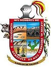
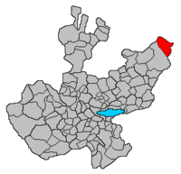
Coat of armsLocation of the municipality in Jalisco Location in Mexico Coordinates: 21°52′N 101°35′W / 21.867°N 101.583°W Country  Mexico
State Jalisco Area – Total 1,156.71 km2 (446.6 sq mi) Population (2005) – Total 28,081 Time zone Central Standard Time (UTC-6) – Summer (DST) Central Daylight Time (UTC-5) Ojuelos de Jalisco is a colonial town and municipality in the state of Jalisco, Mexico. The town's 1990 population was 7,265 [1], although by the year 2000 it had increased to 9,338 [2]. It sits at the junction of Mexico Highways 51, 70, and 80. The town was founded by Spanish conquistador Pedro Casillas de Avila in 1569, as a fortification to protect travelers against the Chichimecas warriors.
The fortification of Ojuelos was one of the seven ones built at the request of the Vice King Martín Enriquez de Almanza in the important route Mexico-Zacatecas. The decision to build the seven fortifications was made by Enriquez de Almanza in response to deadly attacks made by Chichimecas commanded by their legendary leader Maxorro.
Ojuelos has a significant historical value, since its fortification is the only one which has survived to present day. Currently, it houses the offices of the City Hall and a Library, but still it keeps its original design.
Among other touristic attractions, Ojuelos also has a plaza, El Parian, which is surrounded by 102 gotic archs. El Parian was designed at the end of the XIX Century by Luis G. Maciel.
In 1874, Ojuelos was designated as Municipality by Ignacio L. Vallarta, Governor of the State of Jalisco.
External links
Coordinates: 21°52′N 101°35′W / 21.867°N 101.583°W
Municipalities
and
(municipal seats)Acatic · Acatlán de Juárez · Ahualulco de Mercado · Amacueca · Amatitán · Ameca · Arandas · Atemajac de Brizuela · Atengo · Atenguillo · Atotonilco El Alto · Atoyac · Autlán de Navarro · Ayotlán · Ayutla · Bolaños · Cabo Corrientes (El Tuito) · Cañadas de Obregón · Casimiro Castillo · Chapala · Chimaltitán · Chiquilistlán · Cihuatlán · Cocula · Colotlán · Concepción de Buenos Aires · Cuautitlán de García Barragán · Cuautla · Cuquío · Degollado · Ejutla · El Arenal · El Grullo · El Limón · El Salto · Encarnación de Diaz · Etzatlán · Gómez Farías (San Sebastián del Sur) · Guachinango · Guadalajara · Hostotipaquillo · Huejúcar · Huejuquilla El Alto · Ixtlahuacán de los Membrillos · Ixtlahuacan del Río · Jalostotitlán · Jamay · Jesús María · Jilotlán de los Dolores · Jocotepec · Juanacatlán · Juchitlán · La Barca · La Huerta · La Manzanilla · La Manzanilla de La Paz · Lagos de Moreno · Magdalena · Mascota · Mazamitla · Mexticacan · Mezquitic · Mixtlán · Ocotlán · Ojuelos de Jalisco · Píhuamo · Poncitlán · Puerto Vallarta · Quitupan · San Cristobal de la Barranca · San Diego de Alejandría · San Gabriel · San Ignacio · San Juan de los Lagos · San Juanito de Escobedo (Antonio Escobedo) · San Julián, Jalisco · San Marcos · San Martín de Bolaños · San Martín de Hidalgo · San Miguel El Alto · San Sebastián del Oeste · Santa María del Oro · Santa María de los Angeles · Sayula · Tala · Talpa de Allende · Tamazula de Gordiano · Tapalpa · Tecalitlán · Techaluta de Montenegro · Tecolotlán · Tenamaxtlán · Teocaltiche · Teocuitatlán de Corona · Tepatitlán de Morelos · Tequila · Teuchitlán · Tizapan El Alto · Tlajomulco de Zuñiga · Tlaquepaque · Tolimán · Tomatlán · Tonalá · Tonaya · Tonila · Totatiche · Tototlán · Tuxcacuesco · Tuxcueca · Tuxpan · Unión de San Antonio · Unión de Tula · Valle de Guadalupe (Northern) · Valle de Guadalupe (Southern) · Valle de Juárez · Villa Corona · Villa Guerrero · Villa Hidalgo · Villa Purificación · Yahualica de González Gallo · Zacoalco de Torres · Zapopan · Zapotiltic · Zapotitlán de Vadillo · Zapotlán del Rey · Zapotlán el Grande · Zapotlanejo
 Categories:
- Municipalities of Jalisco
- Populated places in Jalisco
- Jalisco geography stubs
Wikimedia Foundation. 2010.


