- Ocotlán, Jalisco
-
Ocotlán — Municipality and city — 
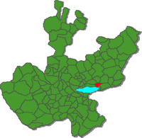
Coat of armsLocation of the municipality in Jalisco Location in Mexico Coordinates: 20°17′20″N 102°50′20″W / 20.28889°N 102.83889°W Country  Mexico
State Jalisco Area – Total 247.7 km2 (95.6 sq mi) Population (2005) – Total 89,340 Time zone Central Standard Time (UTC-6) – Summer (DST) Central Daylight Time (UTC-5) Ocotlán is a city and municipality in Jalisco, Mexico. Its industry includes furniture production.
Contents
Toponymy
The toponym Ocotlán means: "near the pines" or "place of the ocote (pines)". Ocote is from the Náhuatl ocōtl, Pinus montezumae, a species of pine, .
History
Ocotlán was founded in 1530. Two main cathedrals line the plaza. One is the church named La Purisima ("The Most Pure"), which is one of the oldest buildings in Jalisco. The altar is dipped in gold. The other cathedral, more recent than La Purisima, was built in the late 1800s and dedicated to Nuestro Señor de Misericordia (Our Merciful Lord), which honors a vision of Christ seen after an extremely destructive earthquake.
The current municipal president is Lic. Absalón García Ochoa, from the National Action Party.
Story of Nuestro Señor de la Misericordia
On October 2, 1847, a large and powerful earthquake destroyed most of the city, including the original church. The following day, a Sunday, when the faithful were attending a Mass outside of the destroyed church, a vision of the crucifix was claimed to have been seen.
Geography and demographics
Ocotlán borders Poncitlán and Tototlán and is only fifty minutes east-southeast from the city of Guadalajara. It is located on the northeast end of Lake Chapala, Mexico's largest lake. As of the census of 2005 the city of Ocotlán had a population of 81,165. The municipality of Ocotlán, which has an area of 247.7 km² (95.64 sq mi), had a population of 89,340. The proper gentilic for the people is Ocotlense, as in "they are all Ocotlenses." The altitude of the city is 5020 feet, and the time is -6 hours from UTC.
City Businesses
Some of the principal businesses in Ocotlán are Nestlé, Celanese, Forrajes El Nogal,Maderas primas de occidente, Triplay y Aglomerados, Fábrica de Muebles La Cibeles and many other furniture factories like EMMAN, that is an MDF manufacturer.
Architecture
One of the most important building in the city of Ocotlan is the new Library and Media Center Fernando del Paso, recently opened to the public and operated by the Universidad de Guadalajara. This modern building is inspired by the lineal constructions of the university center, it features an impressive lobby of multiple heights in which the main elements of the visual composition of the space are the books themselves. The building was designed by the young architecture firm LeAP, based in Guadalajara. It has been published and exhibited locally and internationally.
List of famous people from Ocotlán
- Carlos Salcido (Tigres de la UANL footballer)
- Alfredo "Pipis" Carrillo(Tacos Ocotlan)
Eddie "Piolín" Sotelo (US Radio personality)
- Johnny Magallon (Chivas de Guadalajara footballer)
- Ismael Íñiguez (Pumas UNAM footballer)
Sister cities
References
- Link to tables of population data from Census of 2005 INEGI: Instituto Nacional de Estadística, Geografía e Informática
- Jalisco Enciclopedia de los Municipios de México
- elcapitolio.net Internet Portal Society
External links
- Ocotlán Ciudad del Mueble Official website www.ocotlanciudaddelmueble.net
- Ocotlán Sitio de la Comunidad Official website www.ocotlanjalisco.net
- Ocotlán Municipal Government Official website
- Map of Ocotlán and surrounding areas
Coordinates: 20°17′20″N 102°50′20″W / 20.28889°N 102.83889°W
Municipalities
and
(municipal seats)Acatic · Acatlán de Juárez · Ahualulco de Mercado · Amacueca · Amatitán · Ameca · Arandas · Atemajac de Brizuela · Atengo · Atenguillo · Atotonilco El Alto · Atoyac · Autlán de Navarro · Ayotlán · Ayutla · Bolaños · Cabo Corrientes (El Tuito) · Cañadas de Obregón · Casimiro Castillo · Chapala · Chimaltitán · Chiquilistlán · Cihuatlán · Cocula · Colotlán · Concepción de Buenos Aires · Cuautitlán de García Barragán · Cuautla · Cuquío · Degollado · Ejutla · El Arenal · El Grullo · El Limón · El Salto · Encarnación de Diaz · Etzatlán · Gómez Farías (San Sebastián del Sur) · Guachinango · Guadalajara · Hostotipaquillo · Huejúcar · Huejuquilla El Alto · Ixtlahuacán de los Membrillos · Ixtlahuacan del Río · Jalostotitlán · Jamay · Jesús María · Jilotlán de los Dolores · Jocotepec · Juanacatlán · Juchitlán · La Barca · La Huerta · La Manzanilla · La Manzanilla de La Paz · Lagos de Moreno · Magdalena · Mascota · Mazamitla · Mexticacan · Mezquitic · Mixtlán · Ocotlán · Ojuelos de Jalisco · Píhuamo · Poncitlán · Puerto Vallarta · Quitupan · San Cristobal de la Barranca · San Diego de Alejandría · San Gabriel · San Ignacio · San Juan de los Lagos · San Juanito de Escobedo (Antonio Escobedo) · San Julián, Jalisco · San Marcos · San Martín de Bolaños · San Martín de Hidalgo · San Miguel El Alto · San Sebastián del Oeste · Santa María del Oro · Santa María de los Angeles · Sayula · Tala · Talpa de Allende · Tamazula de Gordiano · Tapalpa · Tecalitlán · Techaluta de Montenegro · Tecolotlán · Tenamaxtlán · Teocaltiche · Teocuitatlán de Corona · Tepatitlán de Morelos · Tequila · Teuchitlán · Tizapan El Alto · Tlajomulco de Zuñiga · Tlaquepaque · Tolimán · Tomatlán · Tonalá · Tonaya · Tonila · Totatiche · Tototlán · Tuxcacuesco · Tuxcueca · Tuxpan · Unión de San Antonio · Unión de Tula · Valle de Guadalupe (Northern) · Valle de Guadalupe (Southern) · Valle de Juárez · Villa Corona · Villa Guerrero · Villa Hidalgo · Villa Purificación · Yahualica de González Gallo · Zacoalco de Torres · Zapopan · Zapotiltic · Zapotitlán de Vadillo · Zapotlán del Rey · Zapotlán el Grande · Zapotlanejo
 Categories:
- Municipalities of Jalisco
- Populated places in Jalisco
- Populated places established in 1530
Wikimedia Foundation. 2010.


